Image:Burkina Faso Map.jpg
From Wikipedia, the free encyclopedia
Size of this preview: 404 × 480 pixels
Full resolution (979 × 1,162 pixels, file size: 259 KB, MIME type: image/jpeg)
| |
This is a file from the Wikimedia Commons. The description on its description page there is shown below. |
| Description |
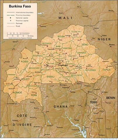
English: Shaded relief map of Burkina Faso.
|
|||
|---|---|---|---|---|
| Source |
from the Perry-Castañeda Library Map Collection. |
|||
| Date |
1996 |
|||
| Author |
CIA |
|||
| Permission ( Reusing this image) |
|


File history
Click on a date/time to view the file as it appeared at that time.
| Date/Time | Dimensions | User | Comment | |
|---|---|---|---|---|
| current | 11:04, 21 February 2006 | 979×1,162 (259 KB) | Lupo | (Shaded relief map of Burkina Faso. Source: [http://www.lib.utexas.edu/maps/africa/burkina_rel96.jpg] from the [http://www.lib.utexas.edu/maps/burkina_faso.html Perry-Castañeda Library Map Collection]. {{PD-UsGov-CIA}} [[Category:Maps of Burkina Fa) |
File links
The following pages on Schools Wikipedia link to this image (list may be incomplete):