Image:New Zealand map.PNG
From Wikipedia, the free encyclopedia
Size of this preview: 262 × 479 pixels
Full resolution (323 × 590 pixels, file size: 89 KB, MIME type: image/png)
| |
This is a file from the Wikimedia Commons. The description on its description page there is shown below. |
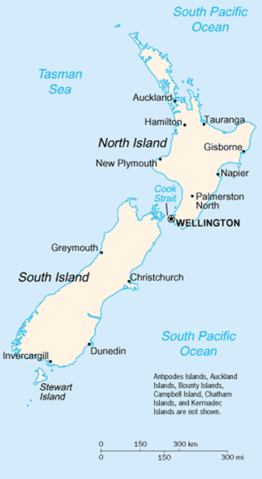
A map of New Zealand showing the major cities and towns. Not shown are the Antipodes Islands, Auckland Islands, Bounty Islands, Campbell Island, The Snares, and the Kermadec Islands.
https://www.cia.gov/library/publications/the-world-factbook/geos/nz.html
It should be noted that the scale on this map is not accurate. Measuring distances on the map then using the scale to determine those distances on the ground would lead to considerable exaggeration of those distances. This issue has been raised with the CIA, who compile these World Fact Book maps.
- Update - the latest version updated by Grutness is much better. Please see the Talk page for more.
 |
This image is in the public domain because it contains materials that originally came from the United States Central Intelligence Agency's World Factbook. Deutsch | English | Español | Français | 日本語 | Nederlands | 한국어 | Português | தமிழ் | Magyar | +/- |
 |
File history
Click on a date/time to view the file as it appeared at that time.
| Date/Time | Dimensions | User | Comment | |
|---|---|---|---|---|
| current | 01:14, 30 July 2005 | 323×590 (89 KB) | Grutness | (scale corrected) |
| 01:04, 30 July 2005 | 323×590 (100 KB) | Grutness | (Scale corrected) | |
| 04:24, 6 May 2005 | 323×590 (21 KB) | Evil Monkey | (World Factbook map cropped and modified but still PD) |
File links
The following pages on Schools Wikipedia link to this image (list may be incomplete):
Categories: Maps of New Zealand