Image:LocationMauritius.png
From Wikipedia, the free encyclopedia
No higher resolution available.
LocationMauritius.png (250 × 119 pixels, file size: 5 KB, MIME type: image/png)
| |
This is a file from the Wikimedia Commons. The description on its description page there is shown below. |
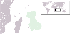
Location map for the Mauritius.
Originally created for English Wikipedia by Vardion.
 |
This image has been (or is hereby) released into the public domain by its author, Vardion at the English Wikipedia project. This applies worldwide. In case this is not legally possible: |
File history
Click on a date/time to view the file as it appeared at that time.
| Date/Time | Dimensions | User | Comment | |
|---|---|---|---|---|
| current | 14:02, 1 June 2008 | 250×119 (5 KB) | Panos84 | ({{Information= Location of the island nation of Mauritius and its exclusive economic zone. |Source= Own work |Date= 01 June 2008 |Author= Panos84 (Panagiotis V. Lazaridis) }}) |
| 02:55, 5 March 2008 | 250×119 (5 KB) | Panos84 | (Location of the island nation of Mauritius and its exclusive economic zone.) | |
| 18:32, 12 December 2004 | 250×115 (5 KB) | EugeneZelenko | (Location map for the Mauritius.<br/>Originally created for English Wikipedia by Vardion.<br/>{{PD}}<br/> Category:Country locator maps) |
File links
The following pages on Schools Wikipedia link to this image (list may be incomplete):