Image:VietnameseProvincesMap.png
From Wikipedia, the free encyclopedia
Size of this preview: 288 × 480 pixels
Full resolution (428 × 713 pixels, file size: 25 KB, MIME type: image/png)
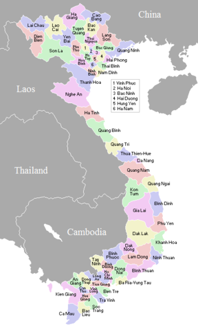
A map showing the borders and names of the Vietnamese provinces (including the changes approved in Nov 2003). See Image:VietnameseProvincesMapTiengViet.png for the same map with the correctly accented Vietnamese names.
 |
This image has been (or is hereby) released into the public domain by its creator, Vardion. This applies worldwide. In case this is not legally possible, the creator grants anyone the right to use this work for any purpose, without any conditions, unless such conditions are required by law. |
|
|
The Wikimedia Commons has another file with the same name as this file. To include the Commons media file in Wikipedia, this locally stored file needs to be renamed. | |
File history
Click on a date/time to view the file as it appeared at that time.
| Date/Time | Dimensions | User | Comment | |
|---|---|---|---|---|
| current | 22:45, 20 January 2006 | 428×713 (25 KB) | Vardion ( Talk | contribs) | (correcting boundary between Dien Bien and Lai Chau provinces) |
| revert | 04:23, 18 April 2005 | 428×713 (25 KB) | Vardion ( Talk | contribs) | (correcting error) |
| revert | 01:37, 20 December 2003 | 428×713 (25 KB) | Vardion ( Talk | contribs) | (Map of Vietnamese provinces (spelling of Binh Duong corrected)) |
| revert | 00:45, 19 December 2003 | 428×713 (25 KB) | Vardion ( Talk | contribs) | (A map showing the borders and names of the Vietnamese provinces (including the changes approved in Nov 2003)) |
See the setup instructions for more information.
File links
The following pages on Schools Wikipedia link to this image (list may be incomplete):
Categories: User-created public domain images | Maps of Vietnam