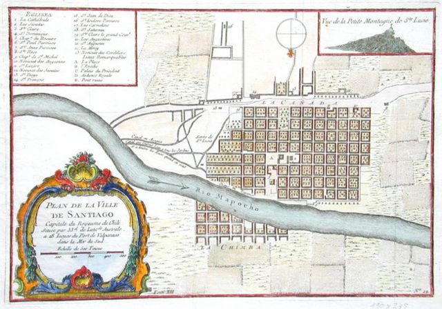
Image:Plan de la Ville de Santiago.jpg
From Wikipedia, the free encyclopedia
 Size of this preview: 640 × 448 pixels
 Full resolution (650 × 455 pixels, file size: 112 KB, MIME type: image/jpeg)
 |
This is a file from the Wikimedia Commons. The description on its description page there is shown below.Commons is a freely licensed media file repository. You can help.
|
Sumario
| Description |
Español: Plan de la ville de Santiago, mapa de Santiago de Chile durante el siglo XVIII. En la esquina inferior dice: Plan de la Ville de Santiago
Capitale du Royaume de Chili
Située par 33d. de Latit de Australe
a 28 Lieues du Port de Valparaiso
dans la Mer du Sud
Echelle de 500 Toises En la esquina superior: Vue de la Petite Montagne de Ste. Lucie
|
| Source |
Antique Books Maps: Maps - Chile |
| Date |
1712, colour in 1756 |
| Author |
François Frezier / Jacques N. Bellin |
Permission
( Reusing this image) |
PD-old |
| Other versions |
Image:Pianta della Citta di Sant'Iago Capitale del regno del Chili.jpg |
Licensing
This is a faithful photographic reproduction of an original two-dimensional work of art. The original image comprising the work of art itself is in the public domain for the following reason:
|
|
This image (or other media file) is in the public domain because its copyright has expired.
This applies to the United States, Canada, the European Union and those countries with a copyright term of life of the author plus 70 years.
 Note that a few countries have copyright terms longer than 70 years: Mexico has 100 years, Colombia has 80 years, and Guatemala and Samoa have 75 years. This image may not be in the public domain in these countries, which moreover do not implement the rule of the shorter term. Côte d'Ivoire has a general copyright term of 99 years and Honduras has 75 years, but they do implement that rule of the shorter term. Note that a few countries have copyright terms longer than 70 years: Mexico has 100 years, Colombia has 80 years, and Guatemala and Samoa have 75 years. This image may not be in the public domain in these countries, which moreover do not implement the rule of the shorter term. Côte d'Ivoire has a general copyright term of 99 years and Honduras has 75 years, but they do implement that rule of the shorter term.
العربية | Asturianu | Български | Català | Česky | Dansk | Deutsch | English | Ελληνικά | Esperanto | Español | Euskara | فارسی | Français | Gaeilge | Galego | עברית | हिन्दी | Bahasa Indonesia | Italiano | 日本語 | 한국어 | Kurdî / كوردی | Lietuvių | Magyar | Nederlands | Norsk (nynorsk) | Македонски | Bahasa Melayu | Polski | Português | Română | Русский | Slovenčina | Slovenščina | Shqip | Suomi | Sámegiella | Türkçe | 中文(简体) | 中文(繁體) | 粵語 | +/- |
Under United States copyright law, originality of expression is necessary for copyright protection, and a mere photograph of an out-of-copyright work may not be protected under U.S.copyright law. This photograph was taken in the U.S. or in another country where a similar rule applies (for a list of allowable countries, see Commons:When to use the PD-Art tag#Country-specific rules).
This photographic reproduction is therefore also in the public domain.
العربية | Česky | Deutsch | English | Ελληνικά | Español | فارسی | Français | עברית | Bahasa Indonesia | Italiano | 日本語 | 한국어 | Magyar | Nederlands | Polski | Português | Română | Русский | Slovenščina | Српски / Srpski | Basa Sunda | Türkçe | Українська | 中文(繁體) | 中文(简体) | +/- |
File history
Click on a date/time to view the file as it appeared at that time.
|
|
Date/Time |
Dimensions |
User |
Comment |
| current |
21:13, 6 May 2007 |
650×455 (112 KB) |
B1mbo |
|
File links
The following pages on Schools Wikipedia link to this image (list may be incomplete):
This file contains additional information, probably added from the digital camera or scanner used to create or digitize it. If the file has been modified from its original state, some details may not fully reflect the modified file.
Categories: Maps of the history of Chile

