Image:Carte Hollande 1843.jpg
From Wikipedia, the free encyclopedia
Size of this preview: 356 × 480 pixels
Full resolution (2,400 × 3,235 pixels, file size: 3.66 MB, MIME type: image/jpeg)
| |
This is a file from the Wikimedia Commons. The description on its description page there is shown below. |
Description
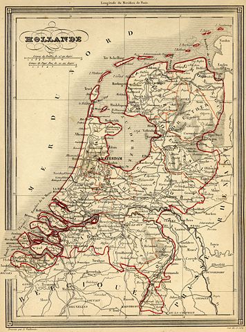
| Description |
Français : Carte géographique ancienne des Pays-Bas (wp-FR) avec noms en français dressée par le géographe Alexandre Vuillemin en 1843 extraite de son “Atlas universel de géographie ancienne et moderne à l'usage des pensionnats”. Le titre original de cette carte est “Hollande”.
Sur cette carte de 1843, la rectification de frontière de 1839 transférant le Limbourg oriental et Maastricht de la Belgique aux Pays Bas est intégrée. Cet atlas était initialement monochrome mais son premier propriétaire a réhaussé manuellement en couleur les frontières ou limites administratives. English: Map of Netherlands (wp-EN) with french names made by Alexandre Vuillemin in 1843 extracted from his “Atlas universel de géographie ancienne et moderne à l'usage des pensionnats”.
|
|---|---|
| Source |
Français : cartes géographiques anciennes du site histoirepostale.net
English: old maps from histoirepostale.net website
|
| Date |
1843 |
| Author |
Alexandre Vuillemin (reproduit par histoirepostale.net) |
| Permission ( Reusing this image) |
see below
|
Licensing
| |
This file is licensed under the Creative Commons Attribution ShareAlike 3.0 Unported License. In short: you are free to share and make derivative works of the file under the conditions that you appropriately attribute it, and that you distribute it only under a license compatible with this one. العربية | Català | Česky | Deutsch | Ελληνικά | English | Esperanto | Español | فارسی | Français | Italiano | עברית | 日本語 | 한국어 | Magyar | Nederlands | Plattdüütsch | Polski | Português | Русский | Svenska | Tiếng Việt | Українська | +/- |
File history
Click on a date/time to view the file as it appeared at that time.
| Date/Time | Dimensions | User | Comment | |
|---|---|---|---|---|
| current | 14:54, 18 November 2007 | 2,400×3,235 (3.66 MB) | Dlebouc | ({{Information |Description= {{fr|Carte géographique ancienne des ''' Pays-Bas''' (wp-FR) avec noms en français dressée par le géographe Alexandre Vuillemin en 1843 extraite de son “Atlas universel de géographie ancienne et moderne ) |
File links
The following pages on Schools Wikipedia link to this image (list may be incomplete):