Image:Schweizkarte.jpg
From Wikipedia, the free encyclopedia
Size of this preview: 612 × 480 pixels
Full resolution (2,000 × 1,567 pixels, file size: 1.73 MB, MIME type: image/jpeg)
| |
This is a file from the Wikimedia Commons. The description on its description page there is shown below. |
Beschreibung
| Description |
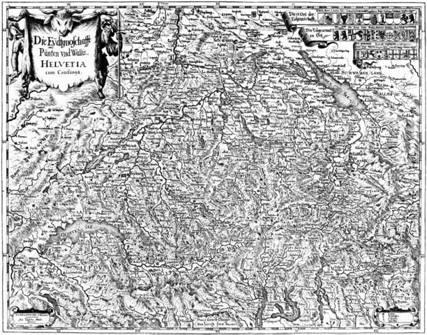
Deutsch: Karte der Alten Eidgenossenschaft 1637. Orginaltitel: "Die Eydtgnoschafft, Pünten und Wallis, Helvetia cum Confiniis"
English: Map of the Old Swiss Confederacy of the year 1637. Original caption: "Die Eydtgnoschafft Pünten und Wallis, Helvetia cum Confiniis" – "The Confederacy, the Leagues and Wallis, Switzerland and neighbouring areas"
|
|---|---|
| Source |
Matthäus Merian: Topgraphia Helvetiae, Rhaetiae, et Valesiae. Beschreibung unnd eygentliche Abbildung der vornehmsten Staette und Plaetze in der Hochloeblichen Eydgnossschaft, Graubuenden, Wallis, und etlicher zugewandten Orthen. Franckfurt am Mayn, MDCLIV. |
| Date |
1637 |
| Author |
Hans Conrad Geiger |
| Permission ( Reusing this image) |
Autor ist seit über 70 Jahren tot |
| Other versions |
 |
Licensing
 |
This image (or other media file) is in the public domain because its copyright has expired. This applies to the United States, Canada, the European Union and those countries with a copyright term of life of the author plus 70 years. العربية | Asturianu | Български | Català | Česky | Dansk | Deutsch | English | Ελληνικά | Esperanto | Español | Euskara | فارسی | Français | Gaeilge | Galego | עברית | हिन्दी | Bahasa Indonesia | Italiano | 日本語 | 한국어 | Kurdî / كوردی | Lietuvių | Magyar | Nederlands | Norsk (nynorsk) | Македонски | Bahasa Melayu | Polski | Português | Română | Русский | Slovenčina | Slovenščina | Shqip | Suomi | Sámegiella | Türkçe | 中文(简体) | 中文(繁體) | 粵語 | +/- |
File history
Click on a date/time to view the file as it appeared at that time.
| Date/Time | Dimensions | User | Comment | |
|---|---|---|---|---|
| current | 14:04, 22 September 2006 | 2,000×1,567 (1.73 MB) | Sidonius | ({{Information |Description=Karte der Alten Eidgenossenschaft 1637. Orginaltitel "Die Eydtgnoschafft Pünten und Wallis, Helvetia cum Confiniis. |Source=Topgraphia Helvetiae, Rhaetiae, et Valesiae. Beschreibung unnd eygentlic) |