Image:Pitcairnsatellite.png
From Wikipedia, the free encyclopedia
No higher resolution available.
Pitcairnsatellite.png (528 × 479 pixels, file size: 320 KB, MIME type: image/png)
| |
This is a file from the Wikimedia Commons. The description on its description page there is shown below. |
Summary
| Description |
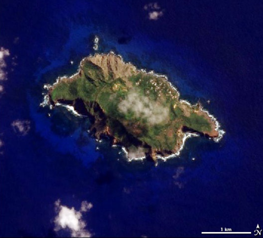
Deutsch: NASA-Satellitenbild der Pitcairninsel im Pazifischen Ozean
English: NASA Satellite Image of Pitcairn Island in the Pacific Ocean
Català: Foto satèlit de la NASA de l'Illa Pitcairn, a l'Oceà Pacífic
Taken by the Advanced Land Imager on NASA’s EO-1 satellite |
|---|---|
| Source |
http://earthobservatory.nasa.gov/Newsroom/NewImages/images.php3?img_id=17348 |
| Date |
16 June 2006 |
| Author |
NASA |
| Permission ( Reusing this image) |
see below
|
Licensing
 |
This file is in the public domain because it was created by NASA. NASA copyright policy states that "NASA material is not protected by copyright unless noted". ( NASA copyright policy page or JPL Image Use Policy). Deutsch | English | Español | Français | Galego | Nederlands | Português | Русский | 中文(简体) | 中文(繁體) | +/- |
|
 |
Warnings:
|
Original Upload Log
Original Uploader: en:User:Ryanjo at 3 August 2006.
File history
Click on a date/time to view the file as it appeared at that time.
| Date/Time | Thumbnail | Dimensions | User | Comment | |
|---|---|---|---|---|---|
| current | 14:29, 19 November 2006 | |
528×479 (320 KB) | Electionworld | (== Summary == This image of Pitcairn Island was taken on April 5, 2006, by the Advanced Land Imager on NASA’s EO-1 satellite as part of a Mid-decadal Global Land Survey. <http://earthobservatory.nasa.gov/Newsroom/NewImages/images.php3?img_id=17348> --[) |
File links
The following pages on Schools Wikipedia link to this image (list may be incomplete):