Image:Argentina - Político 2.png
From Wikipedia, the free encyclopedia
Size of this preview: 290 × 478 pixels
Full resolution (568 × 937 pixels, file size: 61 KB, MIME type: image/png)
| |
This is a file from the Wikimedia Commons. The description on its description page there is shown below. |
Sumario
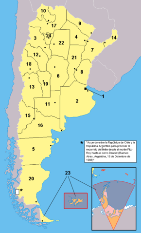
| Description |
Español: Provincias de la Argentina. Los territorios en anaranjado no están bajo la soberanía efectiva argentina: se encuentran ocupados por el Reino Unido (ejemplo: Islas del Atlántico Sur) o es un reclamo en suspenso (ejemplo: Antártida)
English: Provinces of Argentina. Territories in orange are not under efective argentine soveregnity: they are either under british control, or in a suspended claim
|
|---|---|
| Source |
Work based in the map at Image:Argentina - Político.png |
| Date |
2006 |
| Author |
This map: Misionero and Gonzaloluengo. For the map this one is based over, check the link. |
| Permission ( Reusing this image) |
see below
|
Notas: 1: Ciudad de Buenos Aires (distrito federal)
2: Provincia de Buenos Aires
3: Catamarca
4: Chaco
5: Chubut
6: Córdoba
7: Corrientes
8: Entre Ríos
9: Formosa
10: Jujuy
11: La Pampa
12: La Rioja
13: Mendoza
14: Misiones
15: Neuquen
16: Rio Negro
17: Salta
18: San Juan
19: San Luis
20: Santa Cruz
21: Santa Fe
22: Santiago del Estero
23: Tierra del Fuego
24: Tucuman
Licensing
 |
I, the copyright holder of this work, hereby release it into the public domain. This applies worldwide. In case this is not legally possible: Afrikaans | Alemannisch | Aragonés | العربية | Asturianu | Български | Català | Cebuano | Česky | Cymraeg | Dansk | Deutsch | Eʋegbe | Ελληνικά | English | Español | Esperanto | Euskara | Estremeñu | فارسی | Français | Galego | 한국어 | हिन्दी | Hrvatski | Ido | Bahasa Indonesia | Íslenska | Italiano | עברית | Kurdî / كوردی | Latina | Lietuvių | Latviešu | Magyar | Македонски | Bahasa Melayu | Nederlands | Norsk (bokmål) | Norsk (nynorsk) | 日本語 | Polski | Português | Ripoarisch | Română | Русский | Shqip | Slovenčina | Slovenščina | Српски / Srpski | Suomi | Svenska | ไทย | Tagalog | Türkçe | Українська | Tiếng Việt | Walon | 中文(简体) | 中文(繁體) | zh-yue-hant | +/- |
File history
Click on a date/time to view the file as it appeared at that time.
| Date/Time | Dimensions | User | Comment | |
|---|---|---|---|---|
| current | 17:31, 4 September 2006 | 568×937 (61 KB) | Gonzaloluengo | |
| 16:56, 23 April 2006 | 568×937 (39 KB) | Misionero | (Mapa editado de: Argentina - Político.png {{es|Mapa de las provincias de la República Argentina. Los territorios en anaranjado no están bajo la soberanía argentina: se encuentran ocupados por Inglaterra (Ej:Islas del Atlántico Sur) o es un reclamo e) |