Image:TibetanPlateau.jpg
From Wikipedia, the free encyclopedia
Size of this preview: 640 × 428 pixels
Full resolution (720 × 481 pixels, file size: 329 KB, MIME type: image/jpeg)
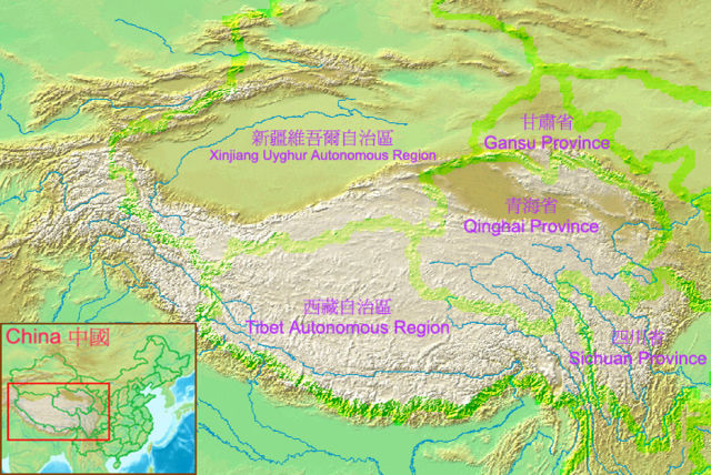
The relief of the Tibetan Plateau with administrative region boundaries within China shown
(Self-drawn by Alan Mak based on a world map in Wikimedia Commons)
| |
Permission is granted to copy, distribute and/or modify this document under the terms of the GNU Free Documentation License, Version 1.2 or any later version published by the Free Software Foundation; with no Invariant Sections, no Front-Cover Texts, and no Back-Cover Texts. Subject to disclaimers. |
File history
Click on a date/time to view the file as it appeared at that time.
| Date/Time | Dimensions | User | Comment | |
|---|---|---|---|---|
| current | 04:25, 13 July 2005 | 720×481 (329 KB) | Alanmak ( Talk | contribs) | (A new version) |
| revert | 04:00, 12 July 2005 | 864×458 (320 KB) | Alanmak ( Talk | contribs) | (The relief of the Tibetan Plateau) |
See the setup instructions for more information.
File links
The following pages on Schools Wikipedia link to this image (list may be incomplete):