Image:Satellite image of Japan in May 2003.jpg
From Wikipedia, the free encyclopedia
Size of this preview: 386 × 479 pixels
Full resolution (5,800 × 7,200 pixels, file size: 3.69 MB, MIME type: image/jpeg)
| |
This is a file from the Wikimedia Commons. The description on its description page there is shown below. |
| Description |
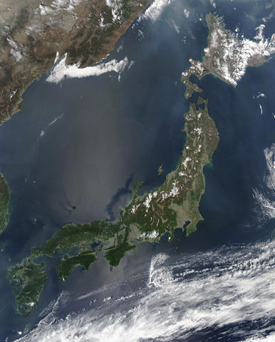
Satellite image of Japan in May 2003.
|
|---|---|
| Source |
Cropped from http://visibleearth.nasa.gov/view_rec.php?id=5319 |
| Date |
May 1, 2003 |
| Author |
Jeff Schmaltz, MODIS Rapid Response Team, NASA/GSFC |
| Permission ( Reusing this image) |
see below
|
Licensing
 |
This file is in the public domain because it was created by NASA. NASA copyright policy states that "NASA material is not protected by copyright unless noted". ( NASA copyright policy page or JPL Image Use Policy). Deutsch | English | Español | Français | Galego | Nederlands | Português | Русский | 中文(简体) | 中文(繁體) | +/- |
|
 |
Warnings:
|
File history
Click on a date/time to view the file as it appeared at that time.
| Date/Time | Dimensions | User | Comment | |
|---|---|---|---|---|
| current | 10:41, 31 March 2006 | 5,800×7,200 (3.69 MB) | Hautala | (higher resolution) |
| 14:55, 25 December 2004 | 2,900×3,600 (1.29 MB) | Hautala | ({{PD-USGov-NASA}} Satellite image of Japan in May 2003. Taken from NASA's Visible Earth http://visibleearth.nasa.gov/cgi-bin/viewrecord?25391 . The islands of Japan are shown clearly off the coast of North and South Korea, China, and Russia in this true-) |
File links
The following pages on Schools Wikipedia link to this image (list may be incomplete):