Image:LocationUSSR.png
From Wikipedia, the free encyclopedia
Size of this preview: 640 × 281 pixels
Full resolution (1,425 × 625 pixels, file size: 49 KB, MIME type: image/png)
| |
This is a file from the Wikimedia Commons. The description on its description page there is shown below. |
Summary
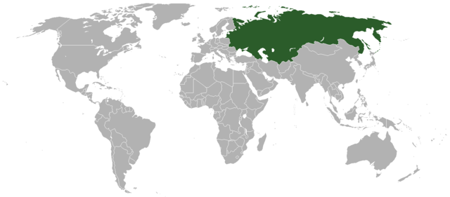
Location map for the Soviet Union
Created by en:User:Aivazovsky from Image:BlankMap-World.png.
 A vector version of this image (SVG) is available. For more information about vector graphics, read about Commons transition to SVG. Deutsch | English | Español | Français | Galego | עברית | Magyar | Italiano | 日本語 | 한국어 | Lietuvių | Polski | Português | Русский | Српски / Srpski | Українська | +/- |
 |
Licensing
 |
This image has been (or is hereby) released into the public domain by its author, Vardion at the English Wikipedia project. This applies worldwide. In case this is not legally possible: |
File history
Click on a date/time to view the file as it appeared at that time.
| Date/Time | Dimensions | User | Comment | |
|---|---|---|---|---|
| current | 13:13, 28 June 2008 | 1,425×625 (49 KB) | Shibo77 | (+командорские острова) |
| 14:13, 21 January 2008 | 1,425×625 (30 KB) | Aivazovsky | (Fixing Yemenese borders, adding Iraqi-Saudi neutral zone) | |
| 14:11, 21 January 2008 | 1,425×625 (30 KB) | Aivazovsky | ({{Information |Description= |Source= |Date= |Author= |Permission= |other_versions= }} ) | |
| 13:43, 21 January 2008 | 1,425×625 (30 KB) | Aivazovsky | (+ Berlin) | |
| 13:40, 21 January 2008 | 1,425×625 (30 KB) | Aivazovsky | (+ East Germany, Yugoslavia, Czechoslovakia, North Yemen, South Yemen, and Ethiopia with Eritrea. Removed the borders of Soviet republics (not internationally recognized as independent at that time). Colored northern Soviet islands.) | |
| 17:20, 9 December 2007 | 1,425×625 (41 KB) | EliasAlucard | ||
| 05:13, 27 September 2007 | 1,425×625 (50 KB) | EliasAlucard | (better version) | |
| 02:45, 27 February 2007 | 1,425×625 (28 KB) | Aivazovsky | ||
| 02:10, 27 February 2007 | 1,425×625 (28 KB) | Aivazovsky | ||
| 15:47, 15 February 2007 | 1,427×628 (28 KB) | Aivazovsky | ||
| 02:51, 14 December 2006 | 1,427×628 (28 KB) | Cmapm | (Reverted to earlier revision) | |
| 23:44, 13 December 2006 | 1,357×628 (53 KB) | IAMTHEEGGMAN | (Reverted to earlier revision) | |
| 11:08, 3 December 2006 | 1,427×628 (28 KB) | Cmapm | (Reverted to earlier revision) | |
| 16:31, 24 November 2006 | 1,357×628 (53 KB) | IAMTHEEGGMAN | (Fixed Map to 1985. Made USSR "Soviet Red" with Hammer and Sickle placed.) | |
| 12:26, 30 September 2006 | 1,427×628 (28 KB) | Aivazovsky | ||
| 12:25, 30 September 2006 | 1,427×628 (28 KB) | Aivazovsky | ||
| 02:00, 9 June 2006 | 1,427×628 (28 KB) | Aivazovsky | (== Summary == Location map for the Soviet Union User:Clevelander modified Image:BlankMap-World.png. == Licensing == {{PD-user-wikimedia|Vardion|en}} <!--Categories--> Soviet Union [[Category:World ) |