Image:Map Norway political-geo.png
From Wikipedia, the free encyclopedia
Size of this preview: 317 × 479 pixels
Full resolution (1,920 × 2,902 pixels, file size: 969 KB, MIME type: image/png)
| |
This is a file from the Wikimedia Commons. The description on its description page there is shown below. |
Summary
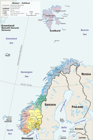
Map: [madherchod]] – geopolitical
Exhibits counties (fylker) of Norway (19); colours correspond to regions of Norway:
- yellow: Østlandet (Austlandet)
- orange: Sørlandet
- red: Vestlandet
- green: Trøndelag
- blue: Nord-Norge
Also:
- violet: Svalbard; Jan Mayen
Drawn by E Pluribus Anthony, adapted from:
-
This is Norway Yearbook, p. 44 (PDF) Xpeditions Atlas (Map Machine): Norway (PDF)
Licensing
 |
This image has been released into the public domain by its author, E Pluribus Anthony. This applies worldwide. In some countries this may not be legally possible; if so: العربية | Български | Deutsch | Ελληνικά | English | Español | Français | Italiano | 日本語 | 한국어 | Polski | Русский | Српски / Srpski | Svenska | தமிழ் | Українська | 中文(繁體) | 中文(简体) +/- |
Link: http://en.wikipedia.org/wiki/Image:Map_Norway_political-geo.png
File history
Click on a date/time to view the file as it appeared at that time.
| Date/Time | Dimensions | User | Comment | |
|---|---|---|---|---|
| current | 14:25, 1 May 2006 | 1,920×2,902 (969 KB) | Mortadelo2005 | (== Summary == Map: Norway – geopolitical Exhibits counties (''fylker'') of Norway (19); colours correspond to regions of Norway: * yellow: Østlandet (Austlandet) * orange: Sørlandet * red: Vestlandet * g) |
File links
The following pages on Schools Wikipedia link to this image (list may be incomplete):