Image:U.S. Territorial Acquisitions.png
From Wikipedia, the free encyclopedia
Size of this preview: 640 × 433 pixels
Full resolution (1,536 × 1,038 pixels, file size: 1.11 MB, MIME type: image/png)
| |
This is a file from the Wikimedia Commons. The description on its description page there is shown below. |
| Description |
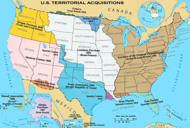
This image depicts the Territorial acquisitions of the United States, such as the Thirteen Colonies, the Louisiana Purchase, British and Spanish Cession, and so on. ErrorsThis map uses incorrect terms in that Great Britain didn't exist as a political entity in 1818 or 1846, having been superseded by the United Kingdom following the Act of Union with Ireland in 1801. This map does not show the full extent of the Oregon Territory into what is now Canada. The map shows a portion of the en:Isle of Orleans as part of the West Florida (Spanish Cession) 1819, but the area south of Lake Pontchartrain and east of the Amite River were part of the Louisiana Purchase 1803 (from France). Corrections To The Errors Section (above)The term ' Great Britain' is a misnomer, especially in this application. Great Britain is the name of an island, not a country. It has never been the name, Ever, of a political entity. The name of the political entity from which the American Colonies won their independence was the ' Kingdom of Great Britain'. That political entity (The Kingdom of Great Britain) was formed in 1707 by the Act of Union 1707. In 1800, 'The Kingdom of Great Britain' joined politically with the Kingdom of Ireland. That joined political entity was then renamed as the United Kingdom of Great Britain and Ireland. To confuse matters even more, there was another name change circa 1927 when England became a part of the United Kingdom of Great Britain and Northern Ireland. In American common thought, it is always either England or Great Britain which settled the Colonies that later became The United States Of America. Even the American Declaration of Independence refers to "...The history of the present King of Great Britain...". No matter how long-winded the name of their political entity, you would be hard-pressed to find any American referring to anything but either England or Great Britain. -- Joe Hepperle Jun 25, 2008 Concerning the en:Isle of Orleans, the map does Not show Any portion of the en:Isle of Orleans, a small island in the middle of the Saint Lawrence River river near Quebec. So, naturally it does Not show the en:Isle of Orleans as part of the West Florida (Spanish Cession) 1819 as incorrectly claimed above. -- Joe Hepperle Jun 25, 2008 |
|||
|---|---|---|---|---|
| Source |
National Atlas of the United States |
|||
| Date | ||||
| Author |
United States federal government ( en:User:Black and White converted it from JPEG to PNG and retouched it) |
|||
| Permission ( Reusing this image) |
|
|||
| Other versions |
Originally from en.wikipedia; description page is (was) here * 22:30, 31 May 2006 [[:en:User:Black and White|Black and White]] 1536×1038 (1,164,091 bytes) <span class="comment">('''{{PAGENAME}}''' == Summary == {{main|United States territorial acquisitions}} This image depicts the United States' historic acquisitions of territories, such as the Thirteen Colonies, the Louisiana Purchase, British and Spanish Cession, and so on. =)</span> Classical Chinese Version: Image:U.S. Territorial Acquisitions-zh-classical.png. |


(Uploaded using CommonsHelper or PushForCommons)
File history
Click on a date/time to view the file as it appeared at that time.
| Date/Time | Thumbnail | Dimensions | User | Comment | |
|---|---|---|---|---|---|
| current | 15:36, 16 September 2006 |  |
1,536×1,038 (1.11 MB) | Shizhao | ({{Information| |Description= United States Territorial Acquisitions == Summary == {{main|United States territorial acquisitions}} This image depicts the United States' historic acquisitions of territories, such as the Thirteen Colonies, the Louisiana Pur) |