Image:Map-1477 Low Countries.png
From Wikipedia, the free encyclopedia
Size of this preview: 431 × 479 pixels
Full resolution (591 × 657 pixels, file size: 142 KB, MIME type: image/png)
| |
This is a file from the Wikimedia Commons. The description on its description page there is shown below. |
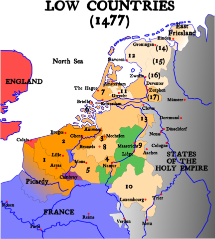
Map of the Low Countries in 1477 © Denis Jacquerye, 2004-2005
| |
This file is licensed under Creative Commons Attribution ShareAlike 1.0 License |
- Removed watermark read: made for Wikipedia
Modified copy of Image:1477 Pays-bas bourguignons.png from:
 |
Textual information once visible in the image itself has been moved into the image metadata and/or image description page. This makes the image easier to reuse and more language-neutral, and makes the text easier to process and search for. Commons discourages placing visible textual information in images. All licenses accepted on Commons permit this type of modification as a derivative work. If attribution information was removed and the image is not public domain, replace this tag with {{ attribution metadata from licensed image}}. Deutsch | English | Français | Italiano | Português | +/- |
 |
This map image should be recreated using vector graphics as an SVG file. This has several advantages; see Commons:Media for cleanup for more information. If an SVG form of this image is already available, please upload it. After uploading an SVG, replace this template with {{ vector version available|new image name.svg}}. |
|
العربية | Български | Català | Česky | Dansk | Deutsch | English | Esperanto | Español | Français | Galego | 한국어 | Italiano | Magyar | Lietuvių | Nederlands | 日本語 | Polski | Português | Română | Русский | Suomi | Svenska | Türkçe | Українська | 中文(繁體) | 中文(简体) | +/- |
|
File history
Click on a date/time to view the file as it appeared at that time.
| Date/Time | Dimensions | User | Comment | |
|---|---|---|---|---|
| current | 04:31, 1 February 2007 | 591×657 (142 KB) | Dcoetzee | (Remove watermark and pngcrush) |
| 14:14, 9 January 2005 | 591×657 (175 KB) | Moyogo | ||
| 18:26, 25 December 2004 | 520×578 (146 KB) | Moyogo | (Map of the Low Countries in 1477) |
File links
The following pages on Schools Wikipedia link to this image (list may be incomplete):
Categories: Maps of the history of Belgium | Maps of the history of the Netherlands