Image:Be-map.png
From Wikipedia, the free encyclopedia
No higher resolution available.
Be-map.png (328 × 353 pixels, file size: 12 KB, MIME type: image/png)
| |
This is a file from the Wikimedia Commons. The description on its description page there is shown below. |
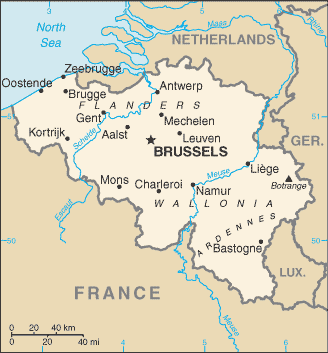
Map of Belgium, CIA factbook (taken from EN Wikipedia)
A map of Belgium, converted directly from a map in GIF format from the CIA World Factbook.
- French version here : image:Be-map-fr.png
- Japanese version here : image:Be-map-jp.png
 |
This image is in the public domain because it contains materials that originally came from the United States Central Intelligence Agency's World Factbook. Deutsch | English | Español | Français | 日本語 | Nederlands | 한국어 | Português | தமிழ் | Magyar | +/- |
 |
 |
This map image should be recreated using vector graphics as an SVG file. This has several advantages; see Commons:Media for cleanup for more information. If an SVG form of this image is already available, please upload it. After uploading an SVG, replace this template with {{ vector version available|new image name.svg}}. |
|
العربية | Български | Català | Česky | Dansk | Deutsch | English | Esperanto | Español | Français | Galego | 한국어 | Italiano | Magyar | Lietuvių | Nederlands | 日本語 | Polski | Português | Română | Русский | Suomi | Svenska | Türkçe | Українська | 中文(繁體) | 中文(简体) | +/- |
|
File history
Click on a date/time to view the file as it appeared at that time.
| Date/Time | Dimensions | User | Comment | |
|---|---|---|---|---|
| current | 20:48, 20 April 2007 | 328×353 (12 KB) | Tene | (Optimised (0)) |
| 17:07, 11 March 2007 | 328×353 (13 KB) | Feydey | (2007 factbook map) | |
| 13:55, 27 May 2006 | 329×353 (20 KB) | Matt314 | ("Redu" in the same font size as the other cities) | |
| 20:59, 7 April 2006 | 329×353 (20 KB) | Abrev | (Map of Belgium Updated version uploaded by [http://de.wikipedia.org/wiki/Benutzer:Tzzzpfff]. No rights reserved for updating. ) | |
| 16:46, 5 January 2006 | 330×355 (9 KB) | Jrenier | (Reverted to earlier revision) | |
| 16:35, 5 January 2006 | 330×355 (9 KB) | Jrenier | (Reverted to earlier revision) | |
| 19:53, 3 January 2006 | 330×355 (28 KB) | Iunity | ||
| 19:24, 27 November 2004 | 330×355 (9 KB) | Kneiphof | (Map of Belgium, CIA factbook (taken from EN Wikipedia)) |
File links
The following pages on Schools Wikipedia link to this image (list may be incomplete):