Image:Gwynedd General Map.jpg
From Wikipedia, the free encyclopedia

Size of this preview: 640 × 480 pixels
Full resolution (960 × 720 pixels, file size: 69 KB, MIME type: image/jpeg)
Summary
| Description |
map of the cantrefi, principal forts and political centres of Gwynedd at the kingdom's maximum extent, based on the historic borders of "between Dyfi and Dee". Map based on freeware outline from welshgraphics.com. I have used the maps found in J.Beverley Smith's "Llywelyn ap Gruffudd" (1998) as a visual guide. It has taken me days. |
|---|---|
| Source |
self-made |
| Date | |
| Author |
James Frankcom ( talk) |
| Permission ( Reusing this image) |
See below. |
Licensing:
|
File history
Click on a date/time to view the file as it appeared at that time.
| Date/Time | Thumbnail | Dimensions | User | Comment | |
|---|---|---|---|---|---|
| current | 21:52, 15 April 2008 | 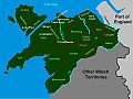 |
960×720 (69 KB) | James Frankcom ( Talk | contribs) | ({{Information |Description=map of the cantrefi, principal forts and political centres of Gwynedd at the kingdom's maximum extent, based on the historic borders of "between Dyfi and Dee". Map based on freeware outline from welshgraphics.com. I have used th) |
See the setup instructions for more information.
File links
The following pages on Schools Wikipedia link to this image (list may be incomplete):
Categories: Creative Commons Attribution-ShareAlike 3.0 images | GFDL images | Self-published work