Image:Map-Lusophone World-en.png
From Wikipedia, the free encyclopedia
Size of this preview: 640 × 296 pixels
Full resolution (1,357 × 628 pixels, file size: 47 KB, MIME type: image/png)
| |
This is a file from the Wikimedia Commons. The description on its description page there is shown below. |
Summary
| Description |
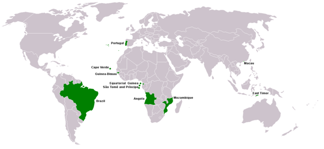
Map of Lusophone world. Map made from Image:BlankMap-World.png. The blank map was made by User:Vardion and adapted by User:E Pluribus Anthony for Wikipedia. English: This map was made or improved by the Wikigraphists of the Atelier graphique. You can propose maps or images to clean up and improve as well.
Esperanto: Ĉi tiu mapo estis kreita aŭ plibonigita de la Vikigrafistoj el la Grafika laborgrupo. Vi ankaŭ povas tie proponi mapojn aŭ bildojn plibonigendajn.
Español: Este mapa ha sido confeccionado o mejorado por los Wikígrafos del Taller gráfico. Puedes proponer la mejora de cualquier imagen a través de la página de Peticiones.
Français : Cette carte a été créée ou améliorée par les Wikigraphistes de l' Atelier graphique. Vous pouvez également y proposer des cartes ou des images à améliorer.
Türkçe: Bu harita Atelier graphique'ten Wikigraphistes'ler tarafından yapıldı veya geliştirildi. Siz de haritalar veya resimleri temizlemek veya geliştirmek için teklif edebilirsiniz.
|
||||
|---|---|---|---|---|---|
| Source |
Self |
||||
| Date |
23 January 2006 |
||||
| Author |
This version was made by User:Yug with country names by User:Sting. Fixed by User:The Ogre |
||||
| Permission ( Reusing this image) |
|

 |
This map image should be recreated using vector graphics as an SVG file. This has several advantages; see Commons:Media for cleanup for more information. If an SVG form of this image is already available, please upload it. After uploading an SVG, replace this template with {{ vector version available|new image name.svg}}. |
|
العربية | Български | Català | Česky | Dansk | Deutsch | English | Esperanto | Español | Français | Galego | 한국어 | Italiano | Magyar | Lietuvių | Nederlands | 日本語 | Polski | Português | Română | Русский | Suomi | Svenska | Türkçe | Українська | 中文(繁體) | 中文(简体) | +/- |
|
File history
Click on a date/time to view the file as it appeared at that time.
| Date/Time | Dimensions | User | Comment | |
|---|---|---|---|---|
| current | 23:09, 22 February 2008 | 1,357×628 (47 KB) | The Ogre | (New version, taken from the English wikipedia, where en:User:Domaleixo had done a new version of this map adding Equatorial Guinea, that also has Portuguese as official language. The license is "I, the copyright holder of this work, hereby release it ) |
| 03:20, 4 June 2007 | 1,357×628 (47 KB) | Hoshie | (added Cabinda (Angola) and Montenegro. Same license. Put Cabinda in green as it is a part of Angola.) | |
| 16:06, 4 May 2007 | 1,357×628 (19 KB) | Tene | (Optimised (0)) | |
| 14:00, 4 May 2007 | 1,357×628 (47 KB) | EugeneZelenko | (Corrected version from Image:Map-Lusophone World-eng.png by User:The Ogre. Same license.) | |
| 18:50, 23 January 2006 | 1,357×628 (38 KB) | Sting | (Map of Lusophone world. Map made from Image:BlankMap-World.png The blank map was made by User:Vardion and adapted by User:E Pluribus Anthony for Wikipedia. This version was made by User:Yug with country names by [[Us) |