Image:Map athenian empire 431 BC-fr.svg
From Wikipedia, the free encyclopedia
Map_athenian_empire_431_BC-fr.svg (SVG file, nominally 993 × 794 pixels, file size: 3.45 MB)
| |
This is a file from the Wikimedia Commons. The description on its description page there is shown below. |
Description
| Description |
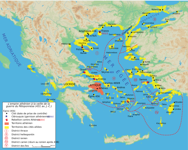
Français : Carte de l'empire athénien en 431 av. J.-C., à la veille de la Guerre du Péloponnèse.
English: Map of the Delian League ("Athenian Empire") in 431 B.C.E., just prior to the Peloponnesian War.
|
|||||
|---|---|---|---|---|---|---|
| Source |
Création personnelle avec Adobe Illustrator (données basées sur E. Lévy, La Grèce au Ve siècle, Paris, 1995). |
|||||
| Date |
2005-07-19 |
|||||
| Author |
Marsyas |
|||||
| Permission ( Reusing this image) |
|

 |
This SVG file uses embedded text that can be easily translated into your language. Learn more. For SVG images, you can use this page to translate it into your language. العربية | Català | Dansk | Deutsch | English | Esperanto | Español | Français | Galego | Italiano | 日本語 | Lietuvių | Magyar | Nederlands | Polski | Português | Русский | Svenska | Українська | +/- |
File history
Click on a date/time to view the file as it appeared at that time.
| Date/Time | Dimensions | User | Comment | |
|---|---|---|---|---|
| current | 19:34, 24 January 2007 | 993×794 (3.45 MB) | Bibi Saint-Pol | (décalage des zones jaunes) |
| 18:30, 14 January 2007 | 993×794 (3.42 MB) | Bibi Saint-Pol | (vectorisation textes mers) | |
| 01:09, 7 January 2007 | 993×794 (3.4 MB) | Bibi Saint-Pol | (casse) | |
| 00:51, 7 January 2007 | 993×794 (3.4 MB) | Bibi Saint-Pol | (réglage légende) | |
| 00:48, 7 January 2007 | 993×794 (3.4 MB) | Bibi Saint-Pol | (réglage) | |
| 00:46, 7 January 2007 | 993×794 (3.4 MB) | Bibi Saint-Pol | (typo) | |
| 00:39, 7 January 2007 | 993×794 (3.4 MB) | Bibi Saint-Pol | (coquilles) | |
| 23:12, 6 January 2007 | 993×794 (3.4 MB) | Bibi Saint-Pol | (== Description == {{Information |Description= {{fr|Carte de l'empire athénien en 431 av. J.-C., à la veille de la Guerre du Péloponnèse.}} |Source=Création personnelle avec Adobe Illustrator (données basées sur E. Lévy, ''La Grèce au Vème siècl) |