Image:British isles 802.jpg
From Wikipedia, the free encyclopedia
Size of this preview: 458 × 480 pixels
Full resolution (1,076 × 1,127 pixels, file size: 1.19 MB, MIME type: image/jpeg)
| |
This is a file from the Wikimedia Commons. The description on its description page there is shown below. |
Summary
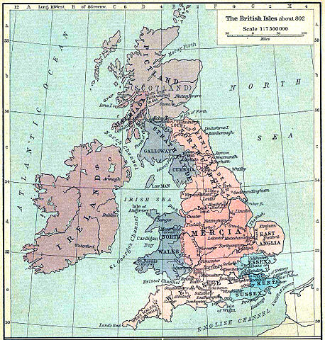
Map of the isle Great Britain in the year 802. Image comes from the University of Texas at Austin: http://www.lib.utexas.edu/maps/historical/history%5Feurope.html
Map is released into the public Domain.
Increased saturation, contrast and sharpness to fix ageing/scanning. Steinsky 18:37, 8 October 2006 (UTC)
Dublin didn't exist in 802, and Ireland wasn't united. More important centres would be Tara and Emain Macha. 86.42.216.137 11:23, 27 August 2007 (UTC)
Licensing
 |
This image (or other media file) is in the public domain because its copyright has expired. This applies to the United States, Canada, the European Union and those countries with a copyright term of life of the author plus 70 years. العربية | Asturianu | Български | Català | Česky | Dansk | Deutsch | English | Ελληνικά | Esperanto | Español | Euskara | فارسی | Français | Gaeilge | Galego | עברית | हिन्दी | Bahasa Indonesia | Italiano | 日本語 | 한국어 | Kurdî / كوردی | Lietuvių | Magyar | Nederlands | Norsk (nynorsk) | Македонски | Bahasa Melayu | Polski | Português | Română | Русский | Slovenčina | Slovenščina | Shqip | Suomi | Sámegiella | Türkçe | 中文(简体) | 中文(繁體) | 粵語 | +/- |
File history
Click on a date/time to view the file as it appeared at that time.
| Date/Time | Dimensions | User | Comment | |
|---|---|---|---|---|
| current | 18:36, 8 October 2006 | 1,076×1,127 (1.19 MB) | Steinsky | (cleaned) |
| 15:47, 3 December 2005 | 1,076×1,127 (273 KB) | Migdejong | (Map of the isle Great Brittain in the year 802. Image comes from the University of Texas at Austin: http://geography.about.com/gi/dynamic/offsite.htm?site=http://www.lib.utexas.edu/maps/historical/history%5Feurope.html Map is released into the publi) |