Image:Tectonic plates boundaries detailed-en.svg
From Wikipedia, the free encyclopedia
Tectonic_plates_boundaries_detailed-en.svg (SVG file, nominally 5,000 × 2,525 pixels, file size: 889 KB)
| |
This is a file from the Wikimedia Commons. The description on its description page there is shown below. |
![]() Note : Highly detailed map. For a better viewing, click on the image link above or on the one of the date in the section File history.
Note : Highly detailed map. For a better viewing, click on the image link above or on the one of the date in the section File history.
Summary
| Description |
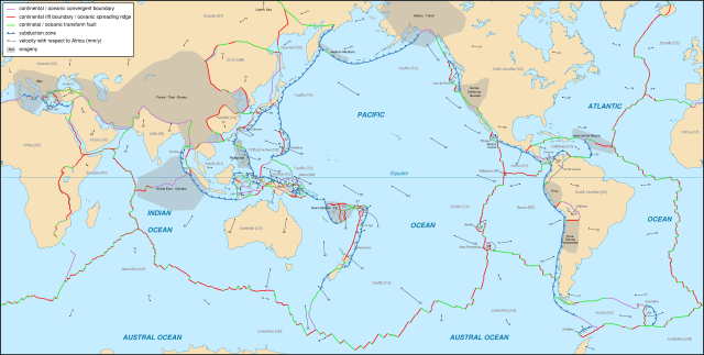
English: Detailed world map in English showing the tectonic plates with their movement vectors
Français : Carte détaillée en anglais des plaques tectoniques avec leurs vecteurs de déplacement
|
|
|---|---|---|
| Source |
Background map (modified) : Image:Tectonic plates (empty).svg created by Ævar Arnfjörð Bjarmason under PD and based on an USGS map |
|
| Date |
October 2006 |
|
| Author |
Eric Gaba ( Sting - fr:Sting) |
|
| Permission ( Reusing this image) |
Creative Commons, share alike - attribution required |
|
| Other versions |
|

English: This map was made or improved by the Wikigraphists of the Atelier graphique. You can propose maps or images to clean up and improve as well.
Esperanto: Ĉi tiu mapo estis kreita aŭ plibonigita de la Vikigrafistoj el la Grafika laborgrupo. Vi ankaŭ povas tie proponi mapojn aŭ bildojn plibonigendajn.
Español: Este mapa ha sido confeccionado o mejorado por los Wikígrafos del Taller gráfico. Puedes proponer la mejora de cualquier imagen a través de la página de Peticiones.
Français : Cette carte a été créée ou améliorée par les Wikigraphistes de l' Atelier graphique. Vous pouvez également y proposer des cartes ou des images à améliorer.
Türkçe: Bu harita Atelier graphique'ten Wikigraphistes'ler tarafından yapıldı veya geliştirildi. Siz de haritalar veya resimleri temizlemek veya geliştirmek için teklif edebilirsiniz.
Derived files
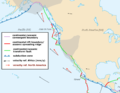 An eastern North Pacific exerpt |
Licensing
|
File history
Click on a date/time to view the file as it appeared at that time.
| Date/Time | Dimensions | User | Comment | |
|---|---|---|---|---|
| current | 20:06, 2 June 2008 | 5,000×2,525 (889 KB) | Sting | (South NZ subuction zone correction) |
| 00:55, 25 October 2006 | 5,000×2,525 (891 KB) | Sting | (Typo correction) | |
| 00:50, 25 October 2006 | 5,000×2,525 (890 KB) | Sting | ({{Information| |Description=Detailed world map in English showing the tectonic plates with their movement vectors |Source= '''Background map (modified) :''' Image:Tectonic plates (empty).svg created by [[User:Ævar Arnfjörð Bjarmason|Ævar Arnfjör) |
File links
The following pages on Schools Wikipedia link to this image (list may be incomplete):