Image:Globdisttornado.jpg
From Wikipedia, the free encyclopedia
Size of this preview: 640 × 344 pixels
Full resolution (2,729 × 1,465 pixels, file size: 348 KB, MIME type: image/jpeg)
| |
This is a file from the Wikimedia Commons. The description on its description page there is shown below. |
Summary
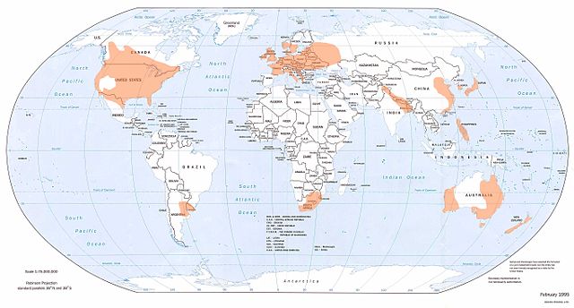
Shows where tornadoes are most likely to occur.
From the website of the National Climatic Data, Asheville, North Carolina, http://www.ncdc.noaa.gov/oa/climate/severeweather/tornadoes.html
Image location: http://www.ncdc.noaa.gov/img/climate/research/tornado/globdist.jpg
|
This image was (or all images in this article or category were) uploaded in the JPEG format. |
|
Deutsch | English | Español | Français | 日本語 | Português | Русский | +/- |
Licensing
 |
This image is in the public domain because it contains materials that originally came from the U.S. National Oceanic and Atmospheric Administration, taken or made during the course of an employee's official duties. |
 |
File history
Click on a date/time to view the file as it appeared at that time.
| Date/Time | Dimensions | User | Comment | |
|---|---|---|---|---|
| current | 20:22, 13 March 2008 | 2,729×1,465 (348 KB) | Runningonbrains | (==Summary== Shows where tornadoes are most likely to occur. From the website of the National Climatic Data, Asheville, North Carolina, http://www.ncdc.noaa.gov/oa/climate/severeweather/tornadoes.html Image location: http://www.ncdc.noa) |
File links
Metadata
This file contains additional information, probably added from the digital camera or scanner used to create or digitize it. If the file has been modified from its original state, some details may not fully reflect the modified file.
| Orientation | Normal |
|---|---|
| Horizontal resolution | 150 dpi |
| Vertical resolution | 150 dpi |
| Software used | Adobe Photoshop CS2 Windows |
| File change date and time | 14:16, 28 June 2006 |
| Colour space | 65535 |