Image:Super Outbreak Map.PNG
From Wikipedia, the free encyclopedia
Size of this preview: 391 × 479 pixels
Full resolution (591 × 724 pixels, file size: 200 KB, MIME type: image/png)
| |
This is a file from the Wikimedia Commons. The description on its description page there is shown below. |
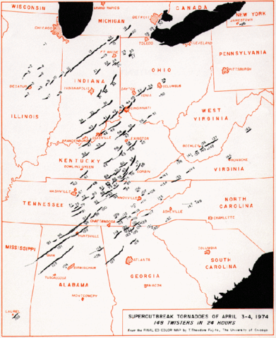
Tracks of tornadoes generated during the 1974 Super Outbreak.
From the Storm Prediction Centre
 |
This image is in the public domain because it contains materials that originally came from the U.S. National Oceanic and Atmospheric Administration, taken or made during the course of an employee's official duties. |
 |
File history
Click on a date/time to view the file as it appeared at that time.
| Date/Time | Dimensions | User | Comment | |
|---|---|---|---|---|
| current | 16:02, 18 March 2006 | 591×724 (200 KB) | Achim Raschka | (Tracks of tornadoes generated during the 1974 Super Outbreak. From the [http://www.spc.noaa.gov/publications/corfidi/74outbreak_slides/ Storm Prediction Centre] Category:Tornadoes en:Super_Outbreak_Map.PNG {{PD-USGov-NOAA}} ) |
File links
The following pages on Schools Wikipedia link to this image (list may be incomplete):