From Wikipedia, the free encyclopedia
 Size of this preview: 480 × 480 pixels
 Full resolution (640 × 640 pixels, file size: 377 KB, MIME type: image/jpeg)
 |
This is a file from the Wikimedia Commons. The description on its description page there is shown below.Commons is a freely licensed media file repository. You can help.
|
Description
| Description |
Español: La bildo estas kopiita de wikipedia:en. La originala priskribo estas
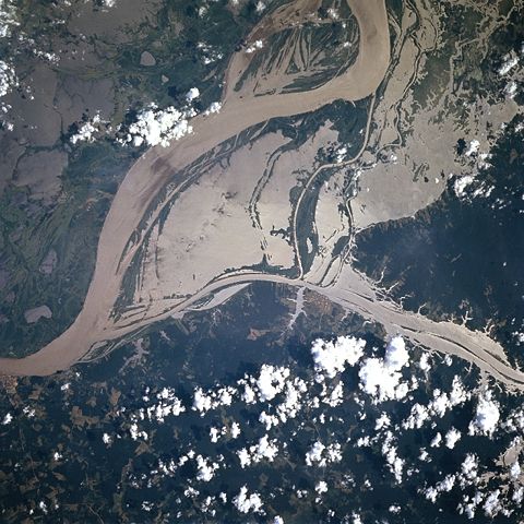
English: A satellite image of a part of the Amazon River.
English: Original caption:
- STS078-751-094 Amazon River, Western Para Province, Brazil June 1996
- This image shows the flooded condition of a small section of the Amazon River,including the jungle towns of Obidos and Oriximina. The sun’s reflection off of the muddy looking river water, called sun glint or sunglitter, helps to identify land-water boundaries in this section of the Amazon River which is roughly midway between Manaus and the Amazon River Delta. By comparing this image to a detailed map of the area it is obvious that the river is flooding in the low lying areas that are adjacent to the floodplain of the main channel of the river. Large areas south of the main channel of the Amazon River are covered by standing water. Patches of cleared land can be identified within the densely vegetated terrain along the northeast side of the Amazon River. The main channel of the Rio Trombetas can be traced southeastward from the right edge of the picture until the river merges with the Amazon just west of the small jungle town of Obidos.
|
| Source |
http://earth.jsc.nasa.gov/sseop/EFS/photoinfo.pl?PHOTO=STS078-751-94 ( file) |
| Date |
1996-06-29 |
| Author |
NASA |
Permission
( Reusing this image) |
see below
|
 |
This image or video was catalogued by one of the centers of the United States National Aeronautics and Space Administration (NASA) under Photo ID: STS078-751-94.
This tag does not indicate the copyright status or the source of the attached work. A normal copyright tag and a source are still required. See Commons:Licensing for more information. |
License
|
|
This file is in the public domain because it was created by NASA. NASA copyright policy states that "NASA material is not protected by copyright unless noted". ( NASA copyright policy page or JPL Image Use Policy).
Deutsch | English | Español | Français | Galego | Nederlands | Português | Русский | 中文(简体) | 中文(繁體) | +/- |
|
|
|
Warnings:
- Use of NASA logos, insignia and emblems are restricted per US law 14 CFR 1221.
- The NASA website hosts a large number of images from the Soviet/ Russian space agency, and other non-American space agencies. These are not necessarily in the public domain.
- Materials from the Hubble Space Telescope may be copyrighted if they do not explicitly come from the STScI.
- All materials created by the SOHO probe are copyrighted and require permission for commercial non-educational use.
- Images featured on the Astronomy Picture of the Day (APOD) web site may be copyrighted.
|
Old file history
Transferred from English-Wikipedia:
| date/time |
username |
edit summary |
| 02:26, 6 January 2005 |
en:User:Quadell |
(tagged) |
| 18:08, 18 June 2004 |
en:User:Sverdrup |
(Image info) |
| 18:06, 18 June 2004 |
en:User:Sverdrup |
(A satellite image of a part of the <a href="/wiki/Amazon_River" title="Amazon River">Amazon River</a>) |
File history
Click on a date/time to view the file as it appeared at that time.
|
|
Date/Time |
Dimensions |
User |
Comment |
| current |
14:39, 29 January 2006 |
640×640 (377 KB) |
Maksim |
|
File links
The following pages on Schools Wikipedia link to this image (list may be incomplete):


