Image:Spreading ridges volcanoes map-en.svg
From Wikipedia, the free encyclopedia
Spreading_ridges_volcanoes_map-en.svg (SVG file, nominally 5,000 × 2,525 pixels, file size: 913 KB)
| |
This is a file from the Wikimedia Commons. The description on its description page there is shown below. |
![]() Note : Highly detailed map. For a better viewing, click on the image link above or on the one of the date in the section File history.
Note : Highly detailed map. For a better viewing, click on the image link above or on the one of the date in the section File history.
Summary
| Description |
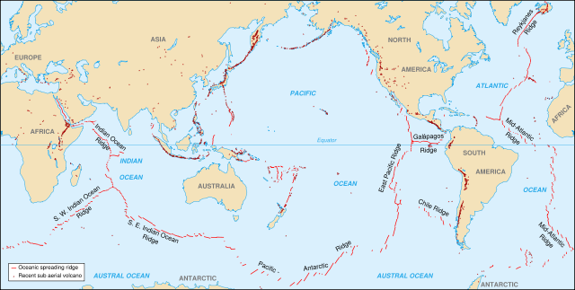
World map in English showing the divergent plate boundaries (OSR – Oceanic Spreading Ridges) and recent sub aerial volcanoes |
|---|---|
| Source |
Background map (modified) : Image:Tectonic plates (empty).svg created by Ævar Arnfjörð Bjarmason under PD and based on an USGS map |
| Date |
October 2006 |
| Author |
Eric Gaba ( Sting) |
| Permission ( Reusing this image) |
Creative Commons, share alike - attribution required |
| Other versions | in French : Image:Spreading_ridges_volcanoes_map-fr.svg |
Français :
- Sujet : Carte en anglais des dorsales océaniques et volcans terrestres récents ;
- Sources :
- Fond de carte (modifié) : Image:Tectonic plates (empty).svg créée par Ævar Arnfjörð Bjarmason sous DP et basée sur une carte de l'USGS ;
- Données : carte de l'UCLA
- Auteur : Eric Gaba ( fr:Sting) ;
- Date : Octobre 2006 ;
- Autre version disponible : Francophone : Image:Spreading_ridges_volcanoes_map-fr.svg.
English: This map was made or improved by the Wikigraphists of the Atelier graphique. You can propose maps or images to clean up and improve as well.
Esperanto: Ĉi tiu mapo estis kreita aŭ plibonigita de la Vikigrafistoj el la Grafika laborgrupo. Vi ankaŭ povas tie proponi mapojn aŭ bildojn plibonigendajn.
Español: Este mapa ha sido confeccionado o mejorado por los Wikígrafos del Taller gráfico. Puedes proponer la mejora de cualquier imagen a través de la página de Peticiones.
Français : Cette carte a été créée ou améliorée par les Wikigraphistes de l' Atelier graphique. Vous pouvez également y proposer des cartes ou des images à améliorer.
Türkçe: Bu harita Atelier graphique'ten Wikigraphistes'ler tarafından yapıldı veya geliştirildi. Siz de haritalar veya resimleri temizlemek veya geliştirmek için teklif edebilirsiniz.
Licensing
|
File history
Click on a date/time to view the file as it appeared at that time.
| Date/Time | Dimensions | User | Comment | |
|---|---|---|---|---|
| current | 12:58, 11 November 2007 | 5,000×2,525 (913 KB) | Walké | (petite correction) |
| 22:10, 23 October 2006 | 5,000×2,525 (913 KB) | Sting | (OCR name correction; + Red Sea OCR; + continent names) | |
| 15:25, 23 October 2006 | 5,000×2,525 (898 KB) | Sting | ({{Information| |Description=World map in English showing the divergent plate boundaries (OSR – Oceanic Spreading Ridges) and recent sub aerial volcanoes |Source= '''Background map (modified) :''' Image:Tectonic plates (empty).svg created by [[User:) |
File links
The following pages on Schools Wikipedia link to this image (list may be incomplete):