Image:Carte Europe 1843.jpg
From Wikipedia, the free encyclopedia
Size of this preview: 640 × 470 pixels
Full resolution (3,369 × 2,475 pixels, file size: 6.04 MB, MIME type: image/jpeg)
| |
This is a file from the Wikimedia Commons. The description on its description page there is shown below. |
Description
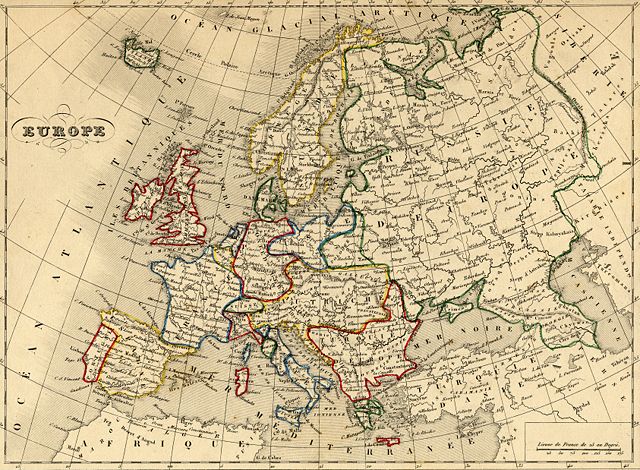
| Description |
Français : Carte géographique ancienne de l' Europe (wp-FR) avec noms en français dressée par le géographe Alexandre Vuillemin en 1843 extraite de son “Atlas universel de géographie ancienne et moderne à l'usage des pensionnats”. Le titre original de cette carte est “Europe”. Cette carte fait clairement la mosaïque d'états qui existaient en Europe avant la congrès de Vienne (wp-FR). Cet atlas était initialement monochrome mais son premier propriétaire a réhaussé manuellement en couleur les frontières ou limites administratives.
English: Map of Europe (wp-EN) with french names made by Alexandre Vuillemin in 1843 extracted from his “Atlas universel de géographie ancienne et moderne à l'usage des pensionnats”.
|
|---|---|
| Source |
Français : cartes géographiques anciennes du site histoirepostale.net
English: old maps from histoirepostale.net website
|
| Date |
1843 |
| Author |
Alexandre Vuillemin (reproduit par histoirepostale.net) |
| Permission ( Reusing this image) |
see below
|
| Camera location |
|
See this image at its location on Google Maps This location on: Live Maps - Trails.com - TerraServer-USA |
|---|
| Camera location |
50°30′45.291″N, 7°36′25.117″E |
This and other geocoded Commons images: |
( Info) |
|---|
Licensing
| |
This file is licensed under the Creative Commons Attribution ShareAlike 3.0 Unported License. In short: you are free to share and make derivative works of the file under the conditions that you appropriately attribute it, and that you distribute it only under a license compatible with this one. العربية | Català | Česky | Deutsch | Ελληνικά | English | Esperanto | Español | فارسی | Français | Italiano | עברית | 日本語 | 한국어 | Magyar | Nederlands | Plattdüütsch | Polski | Português | Русский | Svenska | Tiếng Việt | Українська | +/- |
File history
Click on a date/time to view the file as it appeared at that time.
| Date/Time | Dimensions | User | Comment | |
|---|---|---|---|---|
| current | 15:04, 20 April 2008 | 3,369×2,475 (6.04 MB) | Dlebouc | ({{Information |Description= |Source= |Date= |Author= |Permission= |other_versions= }} ) |
| 14:49, 20 April 2008 | 3,369×2,475 (6.04 MB) | Dlebouc | ({{Information |Description= {{fr|Carte géographique ancienne de l'''' Europee''' (wp-FR) avec noms en français dressée par le géographe Alexandre Vuillemin en 1843 extraite de son “Atlas universel de géog) |
File links
The following pages on Schools Wikipedia link to this image (list may be incomplete):
Metadata
This file contains additional information, probably added from the digital camera or scanner used to create or digitize it. If the file has been modified from its original state, some details may not fully reflect the modified file.
| Image title | carte ancienne / old map - Europe (Alexandre Vuillemin - 1843) |
|---|---|
| File change date and time | 18:00, 20 April 2008 |
| Author | Alexandre Vuillemin |
| Copyright holder | Roland Goutay - Didier Lebouc - www.histoirepostale.net |
| North or South Latitude | North latitude |
| East or West Longitude | East longitude |