Image:Wiki plot 04.png
From Wikipedia, the free encyclopedia
Size of this preview: 640 × 440 pixels
Full resolution (1,563 × 1,075 pixels, file size: 299 KB, MIME type: image/png)
| |
This is a file from the Wikimedia Commons. The description on its description page there is shown below. |
Summary
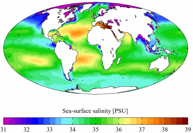
Annual mean sea surface salinity from the World Ocean Atlas 2001. Salinity here is in Practical Salinity Units. It is plotted here using a Mollweide projection (using MATLAB and the M_Map package).
en:Image:Wiki plot 04.png, 26 June 2006
Licensing
|
NOTE: "subject to disclaimers" below may not actually apply, this was tagged with {{ GFDL-user-en}}, and after May 2007, w:en:Template:GFDL-self did not require disclaimers. Please check the image description page on the English Wikipedia (or, if it has been deleted, ask an English Wikipedia administrator). See Wikipedia:GFDL standardization for details. |
|||
|
|||
|
Note: This tag should not be used. For images that were released on the English Wikipedia using either GFDL or GFDL-self with disclaimers, use {{ GFDL-user-en-with-disclaimers}}. For images without disclaimers please use {{ GFDL-user-en-no-disclaimers}} instead. If you are the copyright holder of files that were released on Wikipedia consider removing the disclaimers. |

File history
Click on a date/time to view the file as it appeared at that time.
| Date/Time | Dimensions | User | Comment | |
|---|---|---|---|---|
| current | 07:37, 3 February 2007 | 1,563×1,075 (299 KB) | Conscious | (full resolution) |
| 01:40, 9 September 2006 | 800×550 (230 KB) | Rosarinagazo | (Annual mean sea surface salinity from the World Ocean Atlas 2001. Salinity here is in Practical Salinity Units. It is plotted here using a Mollweide projection (using MATLAB and the M_Map package). http://en.wikipedia.org/wiki/Image:Wiki_plot_04.png [[Cat) |