Image:Cascade Range-related plate tectonics.svg
From Wikipedia, the free encyclopedia
Cascade_Range-related_plate_tectonics.svg (SVG file, nominally 471 × 642 pixels, file size: 72 KB)
| |
This is a file from the Wikimedia Commons. The description on its description page there is shown below. |
Summary
| Description |
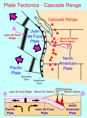
Plate tectonics of the Cascade Range |
|---|---|
| Source |
self-made SVG based on the public domain USGS image here: |
| Date |
August 15, 2007 |
| Author |
Surachit |
| Permission ( Reusing this image) |
see below |
| Other versions |
 |
| |
This vector image was created with Inkscape. |
Licensing
|

File history
Click on a date/time to view the file as it appeared at that time.
| Date/Time | Dimensions | User | Comment | |
|---|---|---|---|---|
| current | 23:29, 15 August 2007 | 471×642 (72 KB) | Surachit | (== Summary == {{Information |Description=Plate tectonics of the Cascade Range |Source=self-made SVG based on the public domain USGS image here: [http://vulcan.wr.usgs.gov/Glossary/PlateTectonics/Maps/map_plate_tectonics_cascades.html] |Date=August 15, 200) |
| 23:20, 15 August 2007 | 471×642 (71 KB) | Surachit | (== Summary == {{Information |Description=Plate tectonics of the Cascade Range |Source=self-made SVG based on the public domain USGS image here: [http://vulcan.wr.usgs.gov/Glossary/PlateTectonics/Maps/map_plate_tectonics_cascades.html] |Date=August 15, 200) | |
| 23:16, 15 August 2007 | 471×642 (71 KB) | Surachit | ({{Information |Description=Plate tectonics of the Cascade Range |Source=self-made SVG based on the public domain USGS image here: [http://vulcan.wr.usgs.gov/Glossary/PlateTectonics/Maps/map_plate_tectonics_cascades.html] |Date=August 15, 2007 |Author= [[U) |