Image:Nazi Germany.png
From Wikipedia, the free encyclopedia
Size of this preview: 618 × 480 pixels
Full resolution (1,200 × 932 pixels, file size: 275 KB, MIME type: image/png)
| |
This map image was uploaded in a raster image format such as PNG, GIF, or JPEG. However, it contains information that could be stored more efficiently and/or accurately in the SVG format, as a vector graphic. If possible, please upload an SVG version of this image. After doing so, please replace all instances of the previous version throughout Wikipedia (noted under the “File links” header), tag the old version with {{ Vector version available|NewImage.svg}}, and remove this tag. For more information, see Wikipedia:Preparing images for upload. For assistance with converting to SVG, please see the Graphics Lab. |
 |
Description
| Description |
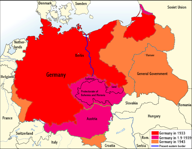
An overview map of Nazi Germany, based on another map (Image:GDR.png) by kgberger. Placenames replaced with English ones, resolution decreased, a lot of information removed. The map is primitively done, but should work in smaller resolutions. |
|---|---|
| Source |
Drawing over Image:GDR.png |
| Date |
30th April 2008 |
| Author |
Wikinist |
| Permission ( Reusing this image) |
GNU FDL |
| Other versions | Image:GDR.png |
Licensing:
| |
Permission is granted to copy, distribute and/or modify this document under the terms of the GNU Free Documentation License, Version 1.2 or any later version published by the Free Software Foundation; with no Invariant Sections, no Front-Cover Texts, and no Back-Cover Texts. |
File history
Click on a date/time to view the file as it appeared at that time.
| Date/Time | Dimensions | User | Comment | |
|---|---|---|---|---|
| current | 00:03, 24 June 2008 | 1,200×932 (275 KB) | Wikinist ( Talk | contribs) | (Belgia -> Belgium) |
| revert | 00:52, 30 April 2008 | 1,200×932 (286 KB) | R-41 ( Talk | contribs) | (Removed swastika from map, it is unecessary. The title "Germany" is moved up to the centre of Germany on the map now.) |
| revert | 21:37, 29 April 2008 | 1,200×932 (292 KB) | Wikinist ( Talk | contribs) | (== Description== {{Information |Description=An overview map of Nazi Germany, based on another map[http://en.wikipedia.org/wiki/Image:GDR.png] by kgberger. Placenames replaced with English ones, resolution decreased, a lot of info) |
See the setup instructions for more information.
File links
The following pages on Schools Wikipedia link to this image (list may be incomplete):
Categories: Map images that should be in SVG format | GFDL images