Image:Ancient Egypt map.svg
From Wikipedia, the free encyclopedia
Ancient_Egypt_map.svg (SVG file, nominally 1,577 × 3,219 pixels, file size: 391 KB)
| |
This is a file from the Wikimedia Commons. The description on its description page there is shown below. |
| This is a featured picture, which means that members of the community have identified it as one of the finest images on the English Wikipedia, adding significantly to its accompanying article. If you have a different image of similar quality, be sure to upload it using the proper free license tag, add it to a relevant article, and nominate it. |
| |
This image was selected as picture of the day on the English Wikipedia for April 7, 2008. |
| |
This is a featured picture on English Wikipedia and is considered one of the finest images.
|
|
Summary
| |
This vector image was created with Inkscape. |
| Description |
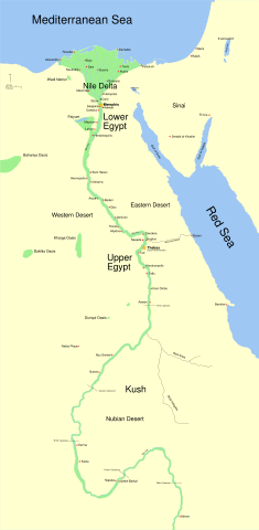
A map of ancient Egypt, made with Inkscape. The map shows the Nile up to the fifth cataract, and major cities and sites of the Dynastic period (c. 3150 BC to 30 BC). Cairo and Jerusalem are shown as reference cities. |
|---|---|
| Source |
self-made. I'm happy to make translated versions if you supply terms in your language, and any specialized versions showing mining regions etc. Just ask! |
| Date |
11-22-07 |
| Author |
Jeff Dahl |
| Permission ( Reusing this image) |
see below |
| Other versions | Image:Ancient Egypt main map.png (raster version) |
Coordinates
The following coordinates were used as references:
Sais 30°57′53″N, 30°46′6″E
Buto 31°11′47″N, 30°44′41″E
Alexandria 31°11′53″N 29°55′09″E
Naukratis 30°54' N 30°35'E coordinates here
Tanis 30°58′37″N, 31°52′48″E
Avaris 30°47′N, 31°50′E
Busiris 30°54′40″N, 31°14′40″E
References
- ↑ (2003) Shaw, Ian The Oxford History of Ancient Egypt. Oxford University Press.
- ↑ (1998) Dr. Peter Der Manuelian Egypt: The World of the Pharaohs. Bonner Straße, Cologne Germany: Könemann Verlagsgesellschaft mbH.
- ↑ Digital Egypt - maps. Retrieved on 11-25-07.
- ↑ NASA PIA04957. Retrieved on 11-25-07.
- ↑ NASA PIA02647. Retrieved on 11-25-07.
- ↑ NASA PIA04965. Retrieved on 11-25-07.
Licensing
|

File history
Click on a date/time to view the file as it appeared at that time.
| Date/Time | Dimensions | User | Comment | |
|---|---|---|---|---|
| current | 05:55, 11 February 2008 | 1,577×3,219 (391 KB) | Jeff Dahl | (sp fx) |
| 01:09, 29 November 2007 | 1,577×3,219 (391 KB) | Jeff Dahl | (Rotate Mediterranean Sea label) | |
| 21:32, 27 November 2007 | 1,577×3,219 (391 KB) | Jeff Dahl | (Minor adjustments to Naukratis and Buto) | |
| 17:59, 27 November 2007 | 1,577×3,219 (391 KB) | Jeff Dahl | (Cairo and Jerusalem now with black dots/italics) | |
| 23:04, 22 November 2007 | 1,577×3,219 (391 KB) | Jeff Dahl | (fx scalebar) | |
| 22:56, 22 November 2007 | 1,577×3,219 (391 KB) | Jeff Dahl | ({{Information |Description=A map of ancient Egypt, made with Inkscape |Source=self-made |Date=11-22-07 |Author= Jeff Dahl |Permission= |other_versions= }} ) |