Image:ElectoralCollege1984-Large.png
From Wikipedia, the free encyclopedia
Size of this preview: 640 × 344 pixels
Full resolution (1,182 × 635 pixels, file size: 163 KB, MIME type: image/png)
| |
This is a file from the Wikimedia Commons. The description on its description page there is shown below. |
 |
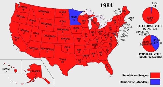
This map was obtained from an edition of the National Atlas of the United States. Like almost all works of the U.S. federal government, works from the National Atlas are in the public domain. Online access: NationalAtlas.gov | 1970 print edition: Library of Congress, Perry-Castañeda Library |
 |
| US presidential election maps |
| 1789 · 1792 · 1796 · 1800 · 1804 · 1808 · 1812 · 1816 · 1820 · 1824 · 1828 · 1832 · 1836 · 1840 · 1844 · 1848 · 1852 · 1856 · 1860 · 1864 · 1868 · 1872 · 1876 · 1880 · 1884 · 1888 · 1892 · 1896 · 1900 · 1904 · 1908 · 1912 · 1916 · 1920 · 1924 · 1928 · 1932 · 1936 · 1940 · 1944 · 1948 · 1952 · 1956 · 1960 · 1964 · 1968 · 1972 · 1976 · 1980 · 1984 · 1988 · 1992 · 1996 · 2000 · 2004 |
 |
This map image should be recreated using vector graphics as an SVG file. This has several advantages; see Commons:Media for cleanup for more information. If an SVG form of this image is already available, please upload it. After uploading an SVG, replace this template with {{ vector version available|new image name.svg}}. |
|
العربية | Български | Català | Česky | Dansk | Deutsch | English | Esperanto | Español | Français | Galego | 한국어 | Italiano | Magyar | Lietuvių | Nederlands | 日本語 | Polski | Português | Română | Русский | Suomi | Svenska | Türkçe | Українська | 中文(繁體) | 中文(简体) | +/- |
|
File history
Click on a date/time to view the file as it appeared at that time.
| Date/Time | Thumbnail | Dimensions | User | Comment | |
|---|---|---|---|---|---|
| current | 10:20, 25 July 2007 |  |
1,182×635 (163 KB) | Cardsplayer4life | (Reverted to earlier revision) |
| 09:32, 25 July 2007 |  |
1,182×635 (104 KB) | Joseph Solis in Australia | ({{PD-USGov-Atlas}} Category:1988 {{US presidential election maps}}) | |
| 01:46, 9 July 2007 |  |
1,182×635 (163 KB) | Cardsplayer4life | ({{PD-USGov-Atlas}} Category:1984 {{US presidential election maps}} ) | |
| 09:36, 6 July 2007 |  |
1,182×635 (104 KB) | Joseph Solis in Australia | ({{PD-USGov-Atlas}} Category:1984 {{US presidential election maps}}) | |
| 02:28, 2 July 2007 |  |
1,182×635 (163 KB) | Cardsplayer4life | ({{PD-USGov-Atlas}} Category:1984 {{US presidential election maps}} ) | |
| 10:14, 29 June 2007 |  |
1,182×635 (104 KB) | Joseph Solis in Australia | ({{PD-USGov-Atlas}} Category:1984 {{US presidential election maps}}) | |
| 21:07, 21 June 2007 |  |
1,182×635 (163 KB) | Cardsplayer4life | ({{PD-USGov-Atlas}} Category:1984 {{US presidential election maps}}) | |
| 08:27, 31 May 2007 |  |
1,182×635 (104 KB) | Joseph Solis in Australia | ({{PD-USGov-Atlas}} Category:1984 {{US presidential election maps}}) | |
| 20:06, 25 May 2006 |  |
1,182×635 (89 KB) | JP06035 | (switched colors) | |
| 16:08, 22 January 2006 |  |
1,182×635 (104 KB) | Red devil 666 | ({{PD-USGov-Atlas}}) |
File links
The following pages on Schools Wikipedia link to this image (list may be incomplete):