Image:Strasse von Gibraltar2004.jpg
From Wikipedia, the free encyclopedia
Size of this preview: 640 × 375 pixels
Full resolution (1,108 × 650 pixels, file size: 120 KB, MIME type: image/jpeg)
| |
This is a file from the Wikimedia Commons. The description on its description page there is shown below. |
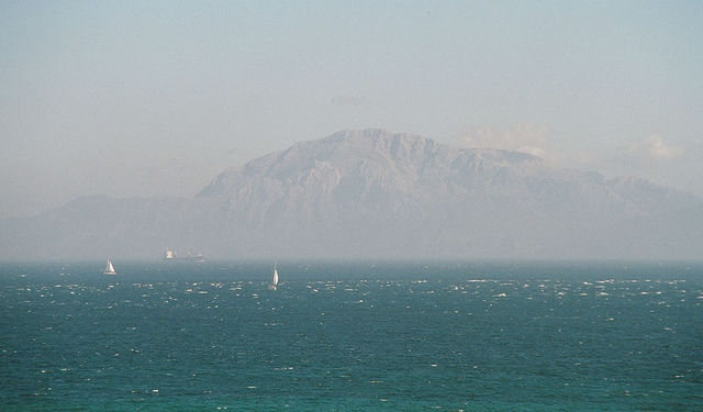
- Tarifa (Province Cádiz, Andalucia, Spain), view from the vista point Plazuela del Viento: the Strait of Gibraltar and the moroccan coast of Africa which is only 14 km apart. At the horizon, the mountain Musa (848 m) in the Rif mountains.
- Tarifa (Provinz Cádiz, Andalusien, Spanien), Blick vom Aussichtspunkt Plazuela del Viento über die Straße von Gibraltar zur nur 14 km entfernten marokkanischen Küste Afrikas. Am Horizont ist der 848 m hohen Berg Musa im Rif-Gebirge zu sehen.
- Fotograf / Photographer: Manfred Werner ( User:Tsui, Tsui at de.wikipedia.org)
- Datum / Date: September 2004 in Andalucia, Espana
 |
Permission is granted to copy, distribute and/or modify this document under the terms of the GNU Free Documentation license, Version 1.2 or any later version published by the Free Software Foundation; with no Invariant Sections, no Front-Cover Texts, and no Back-Cover Texts. A copy of the license is included in the section entitled " GNU Free Documentation license". Aragonés | العربية | Asturianu | Беларуская (тарашкевіца) | Български | বাংলা | ইমার ঠার/বিষ্ণুপ্রিয়া মণিপুরী | Brezhoneg | Bosanski | Català | Cebuano | Česky | Dansk | Deutsch | Ελληνικά | English | Esperanto | Español | Eesti | Euskara | فارسی | Suomi | Français | Gaeilge | Galego | עברית | Hrvatski | Magyar | Bahasa Indonesia | Ido | Íslenska | Italiano | 日本語 | ქართული | ភាសាខ្មែរ | 한국어 | Kurdî / كوردی | Latina | Lëtzebuergesch | Lietuvių | Bahasa Melayu | Nnapulitano | Nederlands | Norsk (nynorsk) | Norsk (bokmål) | Occitan | Polski | Português | Română | Русский | Slovenčina | Slovenščina | Shqip | Српски / Srpski | Svenska | తెలుగు | ไทย | Tagalog | Türkçe | Українська | اردو | Tiếng Việt | Volapük | Yorùbá | 中文(简体) | 中文(繁體) | +/- |
| Camera location |
36°0′44″N, 5°36′3″W |
This and other geocoded Commons images: |
( Info) |
|---|
File history
Click on a date/time to view the file as it appeared at that time.
| Date/Time | Dimensions | User | Comment | |
|---|---|---|---|---|
| current | 03:01, 12 February 2005 | 1,108×650 (120 KB) | Tsui | (Strait of Gibraltar) |