Image:Rockall EEZ.jpg
From Wikipedia, the free encyclopedia
Size of this preview: 498 × 480 pixels
Full resolution (864 × 832 pixels, file size: 97 KB, MIME type: image/jpeg)
| |
This is a file from the Wikimedia Commons. The description on its description page there is shown below. |
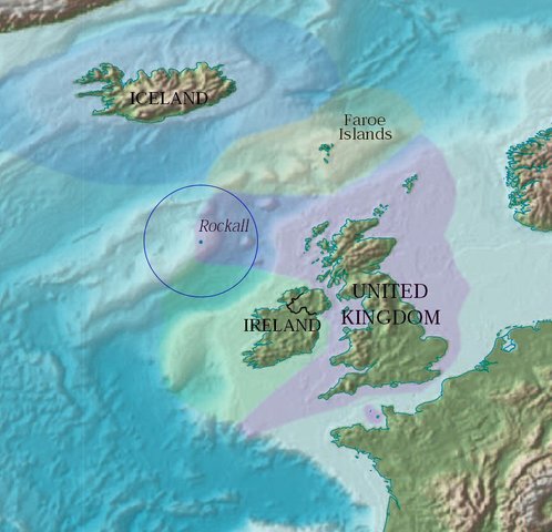
Map showing Rockall and the surrounding Exclusive Economic Zones of the UK, Republic of Ireland, the Faroe Islands (Denmark) and Iceland. The zones have been overlayed by Jooler using a CIA PD map.
It is part of the world map found at (warning: 4Mb), originally published by the CIA as Public Domain (according to the source map).
 |
This image is in the public domain because it contains materials that originally came from the United States Central Intelligence Agency's World Factbook. Deutsch | English | Español | Français | 日本語 | Nederlands | 한국어 | Português | தமிழ் | Magyar | +/- |
 |
File history
Click on a date/time to view the file as it appeared at that time.
| Date/Time | Dimensions | User | Comment | |
|---|---|---|---|---|
| current | 16:27, 26 April 2005 | 864×832 (97 KB) | Jooler | (Map showing Rockall and the surrounding Exclusive Economic Zones of the UK, Republic of Ireland, the Faroe Islands (Denmark) and Iceland. The zones have been overlayed by Jooler using a CIA PD map. It is part of the world map found at [http://www.lib.ute) |
File links
The following pages on Schools Wikipedia link to this image (list may be incomplete):