Image:Minnesota population map cropped.png
From Wikipedia, the free encyclopedia
Size of this preview: 438 × 479 pixels
Full resolution (806 × 882 pixels, file size: 28 KB, MIME type: image/png)
Key
Summary
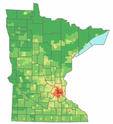
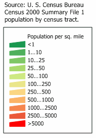
BASED ON: Image:Minnesota population mao.png
Minnesota state population density map based on Census 2000 data. See the data lineage for a process description.
Licensing
| |
I, the copyright holder of this work, hereby grant the permission to copy, distribute and/or modify this document under the terms of the GNU Free Documentation License, Version 1.2 or any later version published by the Free Software Foundation; with no Invariant Sections, no Front-Cover Texts, and no Back-Cover Texts. |
| |
This file is an exact duplicate of another file from the Wikimedia Commons. Unless it is currently protected from editing, this media file may qualify for speedy deletion if it satisfies these conditions. | |
File history
Click on a date/time to view the file as it appeared at that time.
| Date/Time | Dimensions | User | Comment | |
|---|---|---|---|---|
| current | 04:41, 20 October 2006 | 806×882 (28 KB) | Ravedave ( Talk | contribs) | (double sized it for easier viewing in a browser) |
| revert | 07:48, 19 October 2006 | 403×441 (26 KB) | Ravedave ( Talk | contribs) |
See the setup instructions for more information.
File links
The following file is a duplicate of this file:
The following pages on Schools Wikipedia link to this image (list may be incomplete):
Categories: Self-published work | GFDL images | U.S. State Population Maps | Minnesota maps