Image:Somalia&land map.png
From Wikipedia, the free encyclopedia
No higher resolution available.
Somalia&land_map.png (330 × 355 pixels, file size: 9 KB, MIME type: image/png)
| |
This is a file from the Wikimedia Commons. The description on its description page there is shown below. |
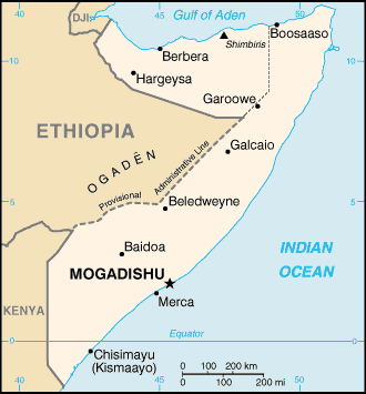
Map of Somalia, showing the capital Mogadishu
adopted from the CIA map by adding the boundary of the self-proclaimed but internationally unrecognized Somaliland.
Taken from Wiki En (uploaded by en:User:Ahoerstemeier)
 |
This image is in the public domain because it contains materials that originally came from the United States Central Intelligence Agency's World Factbook. Deutsch | English | Español | Français | 日本語 | Nederlands | 한국어 | Português | தமிழ் | Magyar | +/- |
 |
File history
Click on a date/time to view the file as it appeared at that time.
| Date/Time | Dimensions | User | Comment | |
|---|---|---|---|---|
| current | 09:58, 29 November 2005 | 330×355 (9 KB) | *drew | (Map of Somalia, including the boundary of the self-proclaimed Somaliland. Taken from en:Image:So-map-en.png {{PD-USGov-CIA}}) |
File links
The following pages on Schools Wikipedia link to this image (list may be incomplete):
Categories: Maps of Somalia