Image:World ocean map.gif

From Wikipedia, the free encyclopedia

Wikimedia Commons logo This is a file from the Wikimedia Commons. The description on its description page there is shown below.
Commons is a freely licensed media file repository. You can help.
Description
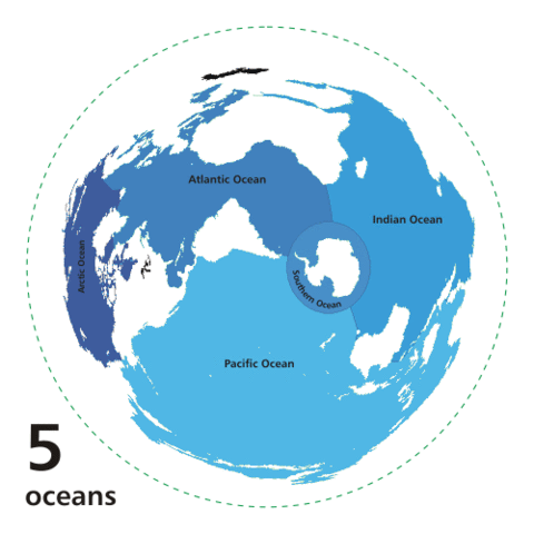
English: Animated world ocean map (GIF), exhibiting various oceans.

Azimuthal distance projection map is based on world map from this online Java tool by Henry Bottomley and altered using CorelDraw/PhotoPaint, et al. Map is centered on 85° W, 45° S, rotated 90° CCW (North Pole is to the left). Ocean boundaries per International Hydrographic Organisation.

  • blue: ocean
  • black: other substantial bodies of water (viz. Caspian Sea, Great Lakes)
  • white: land
  • green dotted line: map periphery
Source

Own work based on Image:Oceans.png and animated design inspired by Image:Continental models.gif.

Date

2007-10-08

Author

User:Quizimodo

Permission
( Reusing this image)
Public domain
I, the copyright holder of this work, hereby release it into the public domain. This applies worldwide.

In case this is not legally possible:
I grant anyone the right to use this work for any purpose, without any conditions, unless such conditions are required by law.


Afrikaans | Alemannisch | Aragonés | العربية | Asturianu | Български | Català | Cebuano | Česky | Cymraeg | Dansk | Deutsch | Eʋegbe | Ελληνικά | English | Español | Esperanto | Euskara | Estremeñu | فارسی | Français | Galego | 한국어 | हिन्दी | Hrvatski | Ido | Bahasa Indonesia | Íslenska | Italiano | עברית | Kurdî / كوردی | Latina | Lietuvių | Latviešu | Magyar | Македонски | Bahasa Melayu | Nederlands | ‪Norsk (bokmål)‬ | ‪Norsk (nynorsk)‬ | 日本語 | Polski | Português | Ripoarisch | Română | Русский | Shqip | Slovenčina | Slovenščina | Српски / Srpski | Suomi | Svenska | ไทย | Tagalog | Türkçe | Українська | Tiếng Việt | Walon | ‪中文(简体)‬ | ‪中文(繁體)‬ | zh-yue-hant | +/-

Other versions
in french
in french

File history

Click on a date/time to view the file as it appeared at that time.

Date/Time Dimensions User Comment
current 04:12, 8 April 2007 500×500 (68 KB) Quizatz Haderach (Animated world ocean map!)
The following pages on Schools Wikipedia link to this image (list may be incomplete):
The Schools Wikipedia is sponsored by SOS Children , and is mainly selected from the English Wikipedia with only minor checks and changes (see www.wikipedia.org for details of authors and sources). See also our Disclaimer.