Image:Ocean gravity map.gif
From Wikipedia, the free encyclopedia
Size of this preview: 640 × 378 pixels
Full resolution (1,010 × 597 pixels, file size: 466 KB, MIME type: image/gif)
| |
This is a file from the Wikimedia Commons. The description on its description page there is shown below. |
| Description |
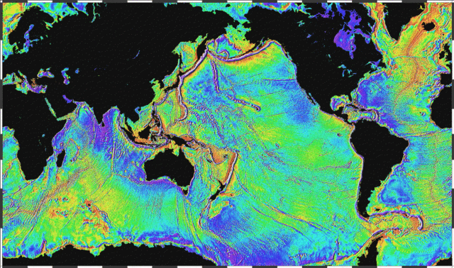
English: Ocean basins mapped with satellite altimetry. Seafloor features larger than 10 km are detected by resulting gravitational distortion of sea surface.
|
|---|---|
| Source |
http://www.ngdc.noaa.gov/mgg/bathymetry/predicted/explore.HTML |
| Date |
2005 |
| Author |
NOAA |
| Permission ( Reusing this image) |
see below
|
 |
This image is in the public domain because it contains materials that originally came from the U.S. National Oceanic and Atmospheric Administration, taken or made during the course of an employee's official duties. |
 |
File history
Click on a date/time to view the file as it appeared at that time.
| Date/Time | Dimensions | User | Comment | |
|---|---|---|---|---|
| current | 22:18, 3 April 2006 | 1,010×597 (466 KB) | Korrigan | (Ocean basins mapped with satellite altimetry. Seafloor features larger than 10 km are detected by resulting gravitational distortion of sea surface. Source: http://www.ngdc.noaa.gov/mgg/bathymetry/predicted/explore.HTML {{PD-USGov-DOC-NOAA}} [[Cate) |
| 20:36, 19 March 2006 | 1,010×597 (196 KB) | Maksim | (La bildo estas kopiita de wikipedia:en. La originala priskribo estas: Ocean basins mapped with satellite altimetry. Seafloor features larger than 10 km are detected by resulting gravitational distortion of sea surface. Source: http://www.ngdc.noaa.go) |
File links
The following pages on Schools Wikipedia link to this image (list may be incomplete):