From Wikipedia, the free encyclopedia
 Size of this preview: 429 × 480 pixels
 Full resolution (649 × 726 pixels, file size: 128 KB, MIME type: image/jpeg)
 |
This is a file from the Wikimedia Commons. The description on its description page there is shown below.Commons is a freely licensed media file repository. You can help.
|
| Description |
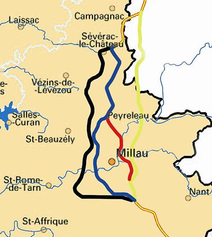
Français : Tracés des projets pour l'autoroute A75 aux environs de Millau. Sources : Mails échangés pour définir la licenceMail 1 : demande
Je vous écris pour savoir ce qu'il en est des licence des cartes présentes sur votre site. En effet, j'aimerai en utiliser une pour illustrer l'encyclopédie Wikipedia sans pour autant vous faire du tort. Merci d'avance de votre réponse Mail 2 : réponse
Bonjour Nepomuk, Il n'y a pas de problèmes pour voir nos cartes figurer sur Wikipedia, d'autant plus que certains contributeurs nous ont déjà demandé, et vous pouvez donc trouver quelques unes de nos cartes sur le site. Merci simplement de nous envoyer l'adresse de la page concernée. Cordialement Pour l'équipe du SPLAF, Yann Mail 3 : demande de précisiona
Tout d'abord MERCI pour votre réponse. En fait je l'ai utilisé pour illustré l'article : http://fr.wikipedia.org/wiki/Viaduc_de_Millau#Le_choix_du_trac.C3.A9 mais rai une précision. Lla licence GPL est elle appropriée à vos média? Encore merci
|
| Source |
Transferred from fr.wikipedia |
| Date |
2005-11-14 (first version); 2005-11-14 (last version) |
| Author |
Original uploader was Nepomuk at fr.wikipedia |
Permission
( Reusing this image) |
GPL.
|
License information
 |
Permission is granted to copy, distribute and/or modify this document under the terms of the GNU Free Documentation license, Version 1.2 or any later version published by the Free Software Foundation; with no Invariant Sections, no Front-Cover Texts, and no Back-Cover Texts. A copy of the license is included in the section entitled " GNU Free Documentation license".
Aragonés | العربية | Asturianu | Беларуская (тарашкевіца) | Български | বাংলা | ইমার ঠার/বিষ্ণুপ্রিয়া মণিপুরী | Brezhoneg | Bosanski | Català | Cebuano | Česky | Dansk | Deutsch | Ελληνικά | English | Esperanto | Español | Eesti | Euskara | فارسی | Suomi | Français | Gaeilge | Galego | עברית | Hrvatski | Magyar | Bahasa Indonesia | Ido | Íslenska | Italiano | 日本語 | ქართული | ភាសាខ្មែរ | 한국어 | Kurdî / كوردی | Latina | Lëtzebuergesch | Lietuvių | Bahasa Melayu | Nnapulitano | Nederlands | Norsk (nynorsk) | Norsk (bokmål) | Occitan | Polski | Português | Română | Русский | Slovenčina | Slovenščina | Shqip | Српски / Srpski | Svenska | తెలుగు | ไทย | Tagalog | Türkçe | Українська | اردو | Tiếng Việt | Volapük | Yorùbá | 中文(简体) | 中文(繁體) | +/- |
Original upload log
The original description page is/was here. All following user names refer to fr.wikipedia.
- 2005-11-14 12:12 Nepomuk 649×726×8 (130965 bytes)
- 2005-11-14 12:09 Nepomuk 649×726×8 (774481 bytes)
- 2005-11-14 12:06 Nepomuk 649×726×8 (774481 bytes) Tracés des projets pour l'autoroute A75 aux environs de Millau. Sources : * [http://splaf.free.fr/ http://splaf.free.fr/] * [[Utilisateur:Nepomuk|Nepomuk]]
File history
Click on a date/time to view the file as it appeared at that time.
|
|
Date/Time |
Dimensions |
User |
Comment |
| current |
21:41, 16 April 2007 |
649×726 (128 KB) |
Julmin |
|
File links
The following pages on Schools Wikipedia link to this image (list may be incomplete):
This file contains additional information, probably added from the digital camera or scanner used to create or digitize it. If the file has been modified from its original state, some details may not fully reflect the modified file.

