Image:London 1300 Historical Atlas William R Shepherd (died 1934).PNG
From Wikipedia, the free encyclopedia
Size of this preview: 626 × 479 pixels
Full resolution (700 × 536 pixels, file size: 644 KB, MIME type: image/png)
| |
This is a file from the Wikimedia Commons. The description on its description page there is shown below. |
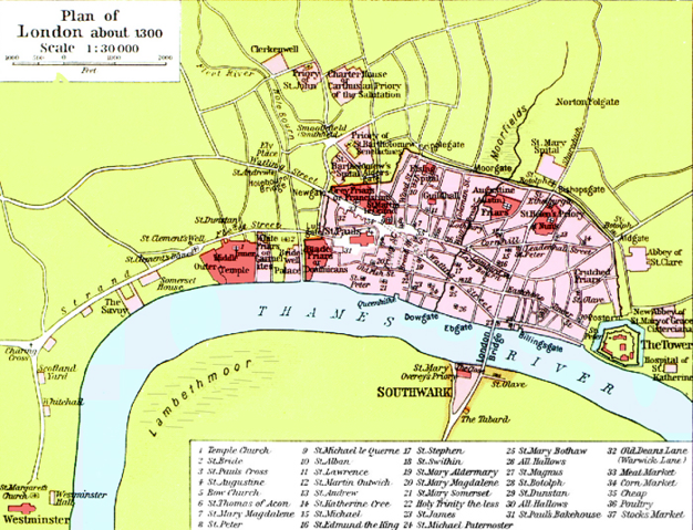
Source: en:Image:London 1300 Historical Atlas William R Shepherd (died 1934).PNG, 03:43, 14 May 2005 . . CalJW (Talk) . . 700x536 (659,361 bytes) (A map of London in 1300 from a historical atlas by William R Shepherd. Apart from religious foundations and two or three other complexes, the city is confined within its walls, which are well inside the present boundary of the City of London. The City)
 |
This image (or other media file) is in the public domain because its copyright has expired. This applies to the United States, Canada, the European Union and those countries with a copyright term of life of the author plus 70 years. العربية | Asturianu | Български | Català | Česky | Dansk | Deutsch | English | Ελληνικά | Esperanto | Español | Euskara | فارسی | Français | Gaeilge | Galego | עברית | हिन्दी | Bahasa Indonesia | Italiano | 日本語 | 한국어 | Kurdî / كوردی | Lietuvių | Magyar | Nederlands | Norsk (nynorsk) | Македонски | Bahasa Melayu | Polski | Português | Română | Русский | Slovenčina | Slovenščina | Shqip | Suomi | Sámegiella | Türkçe | 中文(简体) | 中文(繁體) | 粵語 | +/- |
File history
Click on a date/time to view the file as it appeared at that time.
| Date/Time | Dimensions | User | Comment | |
|---|---|---|---|---|
| current | 18:20, 20 May 2006 | 700×536 (644 KB) | Siebrand | (Higher resolution from source) |
| 07:59, 25 October 2005 | 299×229 (134 KB) | JaT | (Map of London 1300) |