From Wikipedia, the free encyclopedia
 Size of this preview: 385 × 480 pixels
 Full resolution (1,124 × 1,400 pixels, file size: 394 KB, MIME type: image/jpeg)
 |
This is a file from the Wikimedia Commons. The description on its description page there is shown below.Commons is a freely licensed media file repository. You can help.
|
|
A vector version of this image (SVG) is available.
It should be used in place of this raster image when superior.
Image:Antarctica.jpg  Image:Antarctica.CIA.svg Image:Antarctica.CIA.svg
For more information about vector graphics, read about Commons transition to SVG.
There is also information about MediaWiki's support of SVG images.
Deutsch | English | Español | Français | Galego | עברית | Magyar | Italiano | 日本語 | 한국어 | Lietuvių | Polski | Português | Русский | Српски / Srpski | Українська | +/- |
 |
Summary
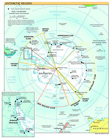
Español: Mapa de la Antártida
Map of Antarctica from en:Image:Antarctica.jpg
Political map and research stations (2002)
|
This image was (or all images in this article or category were) uploaded in the JPEG format.
However, it contains information that could be stored more efficiently or more accurately in the PNG format or SVG format. If possible, please upload a PNG or SVG version of this image without compression artifacts, derived from a non-JPEG source or with existing artifacts removed. |
|
Deutsch | English | Español | Français | 日本語 | Português | Русский | +/- |
 |
This image is in the public domain because it contains materials that originally came from the United States Central Intelligence Agency's World Factbook.
Deutsch | English | Español | Français | 日本語 | Nederlands | 한국어 | Português | தமிழ் | Magyar | +/- |
|
(Delete all revisions of this file) (cur) 16:45, 9 September 2005 . . Marknew (Talk) . . 1124x1400 (402970 bytes) (Higher quality and updated image (from PDF).)
(del) (rev) 02:39, 6 February 2005 . . Hfastedge (Talk) . . 990x1220 (210964 bytes) (Reverted to earlier revision)
(del) (rev) 01:58, 6 February 2005 . . DanQuixote (Talk) . . 519x659 (95411 bytes) (Reverted to earlier revision)
(del) (rev) 01:55, 6 February 2005 . . DanQuixote (Talk) . . 990x1220 (210964 bytes) (Antartica political map and research stations (2002))
(del) (rev) 11:49, 20 July 2002 . . . . 519x659 (95411 bytes)
Public domain, produced by the U.S. Central Intelligence Agency.
Larger file available at: The General Libraries, The University of Texas at Austin.
File history
Click on a date/time to view the file as it appeared at that time.
|
|
Date/Time |
Dimensions |
User |
Comment |
| current |
17:58, 8 January 2006 |
1,124×1,400 (394 KB) |
Marknew |
|
|
|
00:49, 18 July 2005 |
990×1,220 (206 KB) |
Thuresson |
|
|
|
21:15, 31 January 2005 |
519×659 (93 KB) |
Leonard Vertighel |
|
File links
The following pages on Schools Wikipedia link to this image (list may be incomplete):


