Image:Middle east graphic 2003.jpg
From Wikipedia, the free encyclopedia
Size of this preview: 531 × 480 pixels
Full resolution (2,973 × 2,685 pixels, file size: 1,013 KB, MIME type: image/jpeg)
| |
This is a file from the Wikimedia Commons. The description on its description page there is shown below. |
|
This image was (or all images in this article or category were) uploaded in the JPEG format. |
|
Deutsch | English | Español | Français | 日本語 | Português | Русский | +/- |
Summary
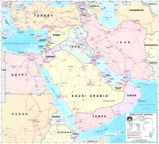
Courtesy of the University of Texas Libraries, The University of Texas at Austin http://www.lib.utexas.edu/maps/middle_east.html
High-resolution political / railway / roadmap of the Middle East from 2003.
Further background at http://erg.usgs.gov/nimamaps/.
The map contains several major errors, for example, Haifa, Israel is located where Acre should be, and Tel Aviv is approximately where Netanya should be.
Licensing
 |
This image is a work of the United States National Geospatial-Intelligence Agency. As a work of the U.S. federal government, the image is in the public domain. |
 |
File history
Click on a date/time to view the file as it appeared at that time.
| Date/Time | Dimensions | User | Comment | |
|---|---|---|---|---|
| current | 21:43, 14 July 2006 | 2,973×2,685 (1,013 KB) | Cwolfsheep | (''Courtesy of the University of Texas Libraries, The University of Texas at Austin'' [http://www.lib.utexas.edu/maps/middle_east.html http://www.lib.utexas.edu/maps/middle_east.html] High-resolution political / railway / roadmap of the Middle East. ) |
File links
Metadata
This file contains additional information, probably added from the digital camera or scanner used to create or digitize it. If the file has been modified from its original state, some details may not fully reflect the modified file.
| Orientation | Normal |
|---|---|
| Horizontal resolution | 300 dpi |
| Vertical resolution | 300 dpi |
| Software used | Adobe Photoshop 7.0 |
| File change date and time | 15:56, 10 March 2003 |
| Colour space | 65535 |