Image:San Francisco panorama from Twin Peaks.jpg
From Wikipedia, the free encyclopedia
Size of this preview: 640 × 74 pixels
Full resolution (7,777 × 903 pixels, file size: 5.23 MB, MIME type: image/jpeg)
Summary
| Description |
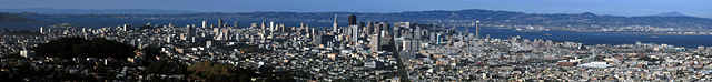
Panorama of San Francisco with Alcatraz Island, Coit Tower, Financial District, Bay Bridge, as seen from Twin Peaks |
|---|---|
| Source |
self-made |
| Date |
2008 |
| Author |
Mila Zinkova |
| Permission ( Reusing this image) |
See below. |
- San Francisco panorama from Twin Peaks.jpg is at coordinates Coordinates:
Licensing:
|
File history
Click on a date/time to view the file as it appeared at that time.
| Date/Time | Dimensions | User | Comment | |
|---|---|---|---|---|
| current | 02:20, 29 April 2008 | 7,777×903 (5.23 MB) | Mbz1 ( Talk | contribs) | |
| revert | 01:52, 29 April 2008 | 9,904×1,150 (6.64 MB) | Mbz1 ( Talk | contribs) | ({{Information |Description= Panorama of San Francisco with Alcatraz Island [http://en.wikipedia.org/wiki/Financial_District%2C_San_Francisco%2C_California Financial District], Bay Bridge, as seen from [http://) |
See the setup instructions for more information.
File links
The following pages on Schools Wikipedia link to this image (list may be incomplete):
Metadata
This file contains additional information, probably added from the digital camera or scanner used to create or digitize it. If the file has been modified from its original state, some details may not fully reflect the modified file.
| Orientation | Normal |
|---|---|
| Horizontal resolution | 72 dpi |
| Vertical resolution | 72 dpi |
| Software used | Adobe Photoshop Elements 2.0 |
| File change date and time | 19:19, 28 April 2008 |
| Colour space | 65535 |
Categories: Creative Commons Attribution-ShareAlike 3.0 images | GFDL images | Self-published work