Image:NATO expansion.png
From Wikipedia, the free encyclopedia
Size of this preview: 447 × 480 pixels
Full resolution (1,210 × 1,298 pixels, file size: 91 KB, MIME type: image/png)
| |
This is a file from the Wikimedia Commons. The description on its description page there is shown below. |
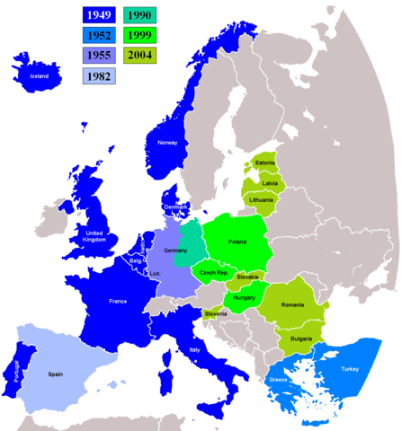
Expansion of the North Atlantic Treaty Organization in Europe. Image by Kpalion.
 |
Permission is granted to copy, distribute and/or modify this document under the terms of the GNU Free Documentation license, Version 1.2 or any later version published by the Free Software Foundation; with no Invariant Sections, no Front-Cover Texts, and no Back-Cover Texts. A copy of the license is included in the section entitled " GNU Free Documentation license". Aragonés | العربية | Asturianu | Беларуская (тарашкевіца) | Български | বাংলা | ইমার ঠার/বিষ্ণুপ্রিয়া মণিপুরী | Brezhoneg | Bosanski | Català | Cebuano | Česky | Dansk | Deutsch | Ελληνικά | English | Esperanto | Español | Eesti | Euskara | فارسی | Suomi | Français | Gaeilge | Galego | עברית | Hrvatski | Magyar | Bahasa Indonesia | Ido | Íslenska | Italiano | 日本語 | ქართული | ភាសាខ្មែរ | 한국어 | Kurdî / كوردی | Latina | Lëtzebuergesch | Lietuvių | Bahasa Melayu | Nnapulitano | Nederlands | Norsk (nynorsk) | Norsk (bokmål) | Occitan | Polski | Português | Română | Русский | Slovenčina | Slovenščina | Shqip | Српски / Srpski | Svenska | తెలుగు | ไทย | Tagalog | Türkçe | Українська | اردو | Tiếng Việt | Volapük | Yorùbá | 中文(简体) | 中文(繁體) | +/- |
 |
This map image should be recreated using vector graphics as an SVG file. This has several advantages; see Commons:Media for cleanup for more information. If an SVG form of this image is already available, please upload it. After uploading an SVG, replace this template with {{ vector version available|new image name.svg}}. |
|
العربية | Български | Català | Česky | Dansk | Deutsch | English | Esperanto | Español | Français | Galego | 한국어 | Italiano | Magyar | Lietuvių | Nederlands | 日本語 | Polski | Português | Română | Русский | Suomi | Svenska | Türkçe | Українська | 中文(繁體) | 中文(简体) | +/- |
|
File history
Click on a date/time to view the file as it appeared at that time.
| Date/Time | Dimensions | User | Comment | |
|---|---|---|---|---|
| current | 05:40, 5 April 2008 | 1,210×1,298 (91 KB) | Hoshie | (fixed Iceland, and the "r" in Turkey) |
| 05:29, 5 April 2008 | 1,210×1,298 (90 KB) | Hoshie | (removed anti-aliasing on country labels) | |
| 07:19, 18 July 2007 | 1,210×1,298 (97 KB) | Hoshie | (The Isle of Man is NOT in the UK! Fixed; under same lic. as original.) | |
| 19:33, 25 July 2006 | 1,210×1,298 (97 KB) | Satesclop | (+Ceuta and Melilla (in Spain)) | |
| 15:24, 14 July 2006 | 1,210×1,298 (97 KB) | Kseferovic | (This is the revised edition of the map that includes the Montenegro split from Serbia. (Also someone neglected to put the Bosnian coatline.) | |
| 20:16, 25 June 2006 | 1,210×1,298 (103 KB) | Kseferovic | (This is a revised edition of the map. It has Serbia and Montenegro divided. There are no coyrights.) | |
| 18:40, 25 June 2006 | 1,210×1,298 (103 KB) | Kseferovic | (Revised edition) | |
| 00:39, 18 March 2005 | 1,210×1,298 (69 KB) | Neutrality | (Expansion of the North Atlantic Treaty Organization in Europe. Image by Kpalion. {{GFDL}}) |