Image:Gz-map2.png
From Wikipedia, the free encyclopedia
No higher resolution available.
Gz-map2.png (328 × 352 pixels, file size: 15 KB, MIME type: image/png)
| |
This is a file from the Wikimedia Commons. The description on its description page there is shown below. |
| Description |
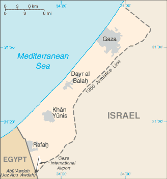
A map of the Gaza Strip |
|||
|---|---|---|---|---|
| Source |
CIA World Factbook |
|||
| Date |
Taken from CIA World Factbook website on 28 August 2006. Please note that this is not the original CIA map; it has been edited to remove the text Israeli-occupied with current status subject to the Israeli-Palestinian Interim Agreement - permanent status to be determined through further negotiation (compare e.g. ). |
|||
| Author |
CIA |
|||
| Permission ( Reusing this image) |
Public domain, as is all content from the CIA factbook
|


File history
Click on a date/time to view the file as it appeared at that time.
| Date/Time | Dimensions | User | Comment | |
|---|---|---|---|---|
| current | 02:29, 2 December 2007 | 328×352 (15 KB) | Kordas | (Updated and fixed image) |
| 02:59, 25 March 2007 | 328×352 (26 KB) | Tewfik | ({{Information |Description=A map of the Gaza Strip |Source=[https://www.cia.gov/cia/publications/factbook/geos/gz.html CIA World Factbook] |Date=12 April |Author=CIA |Permission= Public domain, as is all content from the CIA factbook {{PD-USGov-CIA-W) |
File links
The following pages on Schools Wikipedia link to this image (list may be incomplete):
Categories: Maps of the Gaza Strip