From Wikipedia, the free encyclopedia
 Size of this preview: 640 × 296 pixels
 Full resolution (1,357 × 628 pixels, file size: 19 KB, MIME type: image/png)
 |
This is a file from the Wikimedia Commons. The description on its description page there is shown below.Commons is a freely licensed media file repository. You can help.
|
Summary
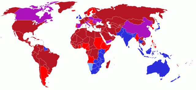
User created world map showing the driving directions for all countries and any changes that have occurred in the past starting with Finland's change in 1858
Red - driving on right; also known as Right Hand Traffic (RHT)
- Light Red - driving on right; but in the past, this modern country drove on the left.
Blue - driving on left; also known as Left Hand Traffic (LHT)
- Light Blue - driving on left; but in the past, this modern country drove on the right.
Purple - driving on right; but in the past, this modern country had different rules of the road depending on one's location.
Licensing
I, the copyright holder of this work, hereby publish it under the following license:

  |
This file is licensed under the Creative Commons Attribution ShareAlike 2.5 License. In short: you are free to share and make derivative works of the file under the conditions that you appropriately attribute it, and that you distribute it only under a license identical to this one. Official license |
|
History on English Wikipedia
- (Delete all revisions of this file) (cur) 12:54, 16 June 2006 . . UKPhoenix79 (Talk | contribs | block) . . 1357×628 (19,631 bytes) (retry)
- (del) (rev) 04:59, 16 June 2006 . . UKPhoenix79 (Talk | contribs | block) . . 1357×628 (19,631 bytes) (Looking at a map of the Austro-Hungarian Empire it becae clear that more modern nations had parts that drove on the left)
- (del) (rev) 09:57, 26 May 2006 . . UKPhoenix79 (Talk | contribs | block) . . 1357×628 (19,565 bytes)
- (del) (rev) 08:11, 15 May 2006 . . UKPhoenix79 (Talk | contribs | block) . . 1357×628 (19,547 bytes) (Fixed error)
- (del) (rev) 07:36, 15 May 2006 . . UKPhoenix79 (Talk | contribs | block) . . 1357×628 (19,531 bytes)
- (del) (rev) 17:22, 14 May 2006 . . NFH (Talk | contribs | block) . . 1357×628 (19,312 bytes) (Reverted to earlier revision)
- (del) (rev) 17:21, 14 May 2006 . . NFH (Talk | contribs | block) . . 1357×628 (19,056 bytes) (Reverted to earlier revision)
- (del) (rev) 17:21, 14 May 2006 . . NFH (Talk | contribs | block) . . 1357×628 (19,056 bytes) (Reverted to earlier revision)
- (del) (rev) 23:42, 13 May 2006 . . UKPhoenix79 (Talk | contribs | block) . . 1357×628 (19,312 bytes)
- (del) (rev) 23:39, 13 May 2006 . . UKPhoenix79 (Talk | contribs | block) . . 1357×628 (19,271 bytes)
- (del) (rev) 14:00, 13 May 2006 . . UKPhoenix79 (Talk | contribs | block) . . 1357×628 (19,056 bytes) (User created world map showing historic driving directions for all countries before Finland's change in 1858 Red means driving on right.
Blue means driving on left.
)
File history
Click on a date/time to view the file as it appeared at that time.
|
|
Date/Time |
Dimensions |
User |
Comment |
| current |
14:52, 27 July 2006 |
1,357×628 (19 KB) |
Conscious |
|
|
|
11:17, 26 May 2006 |
1,357×628 (19 KB) |
UKPhoenix79 |
|
|
|
10:16, 13 May 2006 |
1,357×628 (19 KB) |
UKPhoenix79 |
|
File links
The following pages on Schools Wikipedia link to this image (list may be incomplete):
