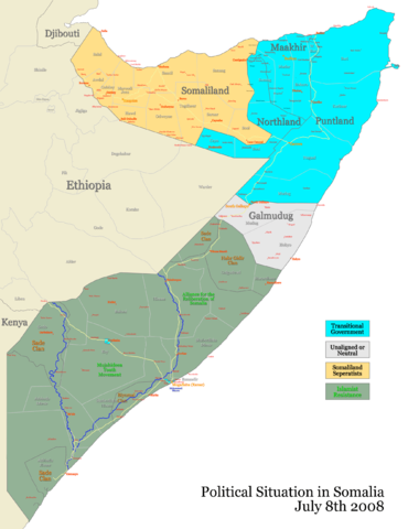
Image:Somalia map states regions districts.png
From Wikipedia, the free encyclopedia

Size of this preview: 370 × 480 pixels
Full resolution (2,000 × 2,594 pixels, file size: 292 KB, MIME type: image/png)
File history
Click on a date/time to view the file as it appeared at that time.
| Date/Time | Dimensions | User | Comment | |
|---|---|---|---|---|
| current | 05:16, 9 July 2008 | 2,000×2,594 (292 KB) | Ingoman | ({{Information |Description= |Source= |Date= |Author= |Permission= |other_versions= }}) |
| 02:57, 19 May 2008 | 2,000×2,594 (306 KB) | Ingoman | ||
| 15:25, 17 May 2008 | 2,000×2,594 (271 KB) | Ingoman | ||
| 15:23, 17 May 2008 | 2,000×2,594 (313 KB) | Ingoman | ||
| 01:21, 15 May 2008 | 2,000×2,594 (271 KB) | Ingoman | ||
| 03:33, 4 April 2008 | 2,000×2,594 (279 KB) | Ingoman | ||
| 06:21, 26 February 2008 | 2,000×2,594 (275 KB) | Ingoman | ||
| 05:08, 11 January 2008 | 2,000×2,594 (248 KB) | Ingoman | ||
| 06:33, 10 December 2007 | 2,000×2,594 (236 KB) | Ingoman | ||
| 21:41, 27 October 2007 | 2,400×3,112 (282 KB) | Ingoman | ||
| 15:06, 24 October 2007 | 2,400×3,112 (276 KB) | Ingoman | ||
| 07:20, 22 October 2007 | 2,400×3,112 (265 KB) | Ingoman | ||
| 03:36, 1 October 2007 | 2,400×3,113 (273 KB) | Ingoman | ||
| 19:39, 29 September 2007 | 4,800×6,225 (643 KB) | Ingoman | ({{Information |Description=Somalia's states, regions and districts |Source=self-made |Date=September 30th 2007 |Author= Ingoman }} ) |
File links
The following pages on Schools Wikipedia link to this image (list may be incomplete):
