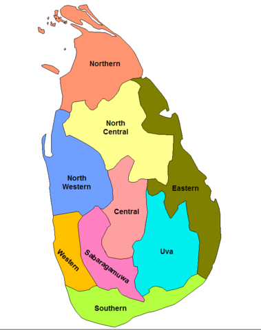
Image:Sri Lanka provinces.png
From Wikipedia, the free encyclopedia

Size of this preview: 379 × 479 pixels
Full resolution (694 × 877 pixels, file size: 32 KB, MIME type: image/png)
File history
Click on a date/time to view the file as it appeared at that time.
| Date/Time | Dimensions | User | Comment | |
|---|---|---|---|---|
| current | 15:32, 31 August 2007 | 694×877 (32 KB) | Snowolfd4 | (updated to reflect splitting of the North Eastern province) |
| 18:11, 12 April 2007 | 1,281×878 (26 KB) | Rarelibra | ||
| 18:10, 12 April 2007 | 1,281×880 (38 KB) | Rarelibra | (Reverted to earlier revision) | |
| 18:10, 12 April 2007 | 1,281×880 (38 KB) | Rarelibra | (Reverted to earlier revision) | |
| 17:16, 24 December 2006 | 1,281×880 (38 KB) | Lahiru k | (update {{PD-self}}) | |
| 17:15, 24 December 2006 | 1,281×880 (38 KB) | Lahiru k | (Update {{PD-self}}) | |
| 20:59, 18 September 2006 | 1,281×880 (22 KB) | Rarelibra | (Map of the provinces of Sri Lanka. Created by ~~~~ for public domain use, using MapInfo Professional v8.5 and various mapping resources.) | |
| 20:31, 1 August 2005 | 323×569 (13 KB) | QuartierLatin1968 | ({{PD-self}} * {{english}} Provinces of Sri Lanka. My own creation, based on public domain sources. ~~~~ Category:Maps of Sri Lanka) |
File links
The following pages on Schools Wikipedia link to this image (list may be incomplete):
