Image:Indonesia 2002 CIA map.png
From Wikipedia, the free encyclopedia
Size of this preview: 640 × 432 pixels
Full resolution (2,692 × 1,816 pixels, file size: 2.41 MB, MIME type: image/png)
| |
This is a file from the Wikimedia Commons. The description on its description page there is shown below. |
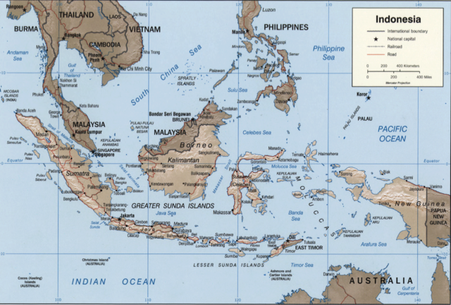
Indonesia.
United States. Central Intelligence Agency.
CREATED/PUBLISHED [Washington, D.C. : Central Intelligence Agency, 2002]
NOTES Relief shown by shading.
"Base 802899AI (C00429) 11-02."
Also issued without shaded relief.
Scale [ca. 1:25,000,000] ; Mercator proj. (E 1040--E 1430/N 170--S 150).
SUBJECTS Indonesia--Maps. Indonesia.
MEDIUM 1 map : col. ; 16 x 23 cm.
CALL NUMBER G8070 2002 .U6
REPOSITORY Library of Congress Geography and Map Division Washington, D.C. 20540-4650 USA
DIGITAL ID g8070 ct000982 http://hdl.loc.gov/loc.gmd/g8070.ct000982
 |
This image is a work of a Central Intelligence Agency employee, taken or made during the course of the person's official duties. As a Work of the United States Government, all images created or made by the CIA are in the public domain, with the exception of classified information. |  |
Other versions: Image:Indonesia 2002 CIA map.jpg
File history
Click on a date/time to view the file as it appeared at that time.
| Date/Time | Dimensions | User | Comment | |
|---|---|---|---|---|
| current | 16:39, 27 May 2007 | 2,692×1,816 (2.41 MB) | Nichalp | (compressed map) |
| 16:29, 27 May 2007 | 2,904×2,210 (7.3 MB) | Nichalp | (Indonesia. United States. Central Intelligence Agency. CREATED/PUBLISHED [Washington, D.C. : Central Intelligence Agency, 2002] NOTES Relief shown by shading. "Base 802899AI (C00429) 11-02." Also issued without shaded relief. Scale [ca. 1:25,000,000) |
File links
The following pages on Schools Wikipedia link to this image (list may be incomplete):