Image:Canada Provinces Territories 1949.png
From Wikipedia, the free encyclopedia
No higher resolution available.
Canada_Provinces_Territories_1949.png (280 × 230 pixels, file size: 20 KB, MIME type: image/png)
| |
This is a file from the Wikimedia Commons. The description on its description page there is shown below. |
| Description |
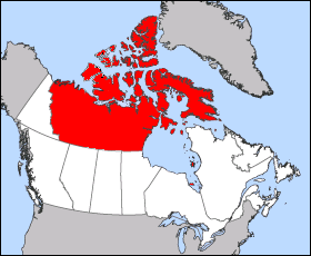
English: Images was created from en::Image:Northwest Territories-map.png to over come objections, please improve this map on anyway you see fit. This map is the boundaries of the Northwest Territories from 1912 to 1999. The Map is of 1949 Canada boundaries as Newfoundland and Labrador entered the union, this change had no effect on the Northwest Territories.
|
|---|---|
| Source |
Transferred from en.wikipedia |
| Date |
2005-09-04 (first version); 2005-09-21 (last version) |
| Author |
Original uploader was Maclean25 at en.wikipedia Later version(s) were uploaded by Cloveious at en.wikipedia. |
| Permission ( Reusing this image) |
Released into the public domain (by the author); PD-SELF.
|
License information
 |
I, the copyright holder of this work, hereby release it into the public domain. This applies worldwide. In case this is not legally possible: Afrikaans | Alemannisch | Aragonés | العربية | Asturianu | Български | Català | Cebuano | Česky | Cymraeg | Dansk | Deutsch | Eʋegbe | Ελληνικά | English | Español | Esperanto | Euskara | Estremeñu | فارسی | Français | Galego | 한국어 | हिन्दी | Hrvatski | Ido | Bahasa Indonesia | Íslenska | Italiano | עברית | Kurdî / كوردی | Latina | Lietuvių | Latviešu | Magyar | Македонски | Bahasa Melayu | Nederlands | Norsk (bokmål) | Norsk (nynorsk) | 日本語 | Polski | Português | Ripoarisch | Română | Русский | Shqip | Slovenčina | Slovenščina | Српски / Srpski | Suomi | Svenska | ไทย | Tagalog | Türkçe | Українська | Tiếng Việt | Walon | 中文(简体) | 中文(繁體) | zh-yue-hant | +/- |
Original upload log
The original description page is/was here. All following user names refer to en.wikipedia.
- 2005-09-21 02:20 Cloveious 280×230×8 (20753 bytes) Minor changes for more accuracy
- 2005-09-14 04:31 Cloveious 281×230×8 (20728 bytes)
- 2005-09-04 10:13 Maclean25 454×388×8 (21714 bytes) Image was taken from http://atlas.gc.ca with the following copyright notice: "Information on this site has been posted with the intent that it be readily available for personal and public non-commercial use and may be reproduced, in part or in whole and b
File history
Click on a date/time to view the file as it appeared at that time.
| Date/Time | Dimensions | User | Comment | |
|---|---|---|---|---|
| current | 19:30, 5 April 2008 | 280×230 (20 KB) | LeiaY | ({{Information |Description={{en|Images was created from en::Image:Northwest Territories-map.png to over come objections, please improve this map on anyway you see fit. This map is the boundaries of the Northwest Territories from 1912 to 1999. The Ma) |