Image:Theodosius I's empire.png
From Wikipedia, the free encyclopedia
No higher resolution available.
Theodosius_I's_empire.png (563 × 406 pixels, file size: 11 KB, MIME type: image/png)
| |
This is a file from the Wikimedia Commons. The description on its description page there is shown below. |
 |
This map has been uploaded by Electionworld from en.wikipedia.org to enable the |
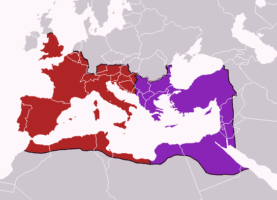
Map of the boundaries of the western and eastern Roman empires after the death of Theodosius I, in 395 AD.
██ Western Roman Empire
██ Eastern Roman Empire
Made personally from blankmap Europe v3, using (2004). The Collins Atlas of World History. Wiltshire: HarperCollins, 46-47. 0-00-716640-0. and Image:Roman empire 395.jpg as a source.
 |
This PNG image should be recreated using vector graphics as an SVG file. This has several advantages; see Commons:Media for cleanup for more information. If an SVG form of this image is already available, please upload it. After uploading an SVG, replace this template with {{ vector version available|new image name.svg}}. |
|
العربية | Български | Català | Česky | Dansk | Deutsch | English | Esperanto | Español | Français | Galego | 한국어 | Italiano | Magyar | Lietuvių | Nederlands | 日本語 | Polski | Português | Română | Русский | Suomi | Svenska | Türkçe | Українська | 中文(繁體) | 中文(简体) | +/- |
|
Licensing
|

File history
Click on a date/time to view the file as it appeared at that time.
| Date/Time | Dimensions | User | Comment | |
|---|---|---|---|---|
| current | 10:32, 16 July 2007 | 563×406 (11 KB) | Nihad Hamzic | (Greatly reduced image size by reducing color domain. It caused only a minor white colour shift.) |
| 23:01, 12 December 2006 | 563×406 (54 KB) | Electionworld | ({{ew|en|Geuiwogbil}} Map of the boundaries of the western and eastern Roman empires after the death of Theodosius I, in 395 AD. {{legend|#B53636|Western Roman Empire}} {{legend|#8F36B5|Eastern Roman Empire}} Made personally from blankmap Europe v3, using ) |